Road trip guide: Conquering China National Highway 219
High altitude, thin, freezing dry air; intense harsh sunlight, galeforce winds with sub-zero windchill for hundreds and hundreds of kilometres. China National Highway 219 (G219) is a true adventure.
What is China's longest National Highway?
It's said to be the longest National Highway in the country. The road, also known as Tibet-Xinjiang Highway, is 10.002km (6214 miles) long. It runs along the southwestern border of the People's Republic of China, from Kom-Kanas (in the Xinjiang Uygur Autonomous Region, on the northwest of the country) to Dongxing (in the Guangxi Zhuang Autonomous Region of South China, near the border with Vietnam). Several stretches of the road are known to many as "no man's land".
Is China National Highway 219 challenging?
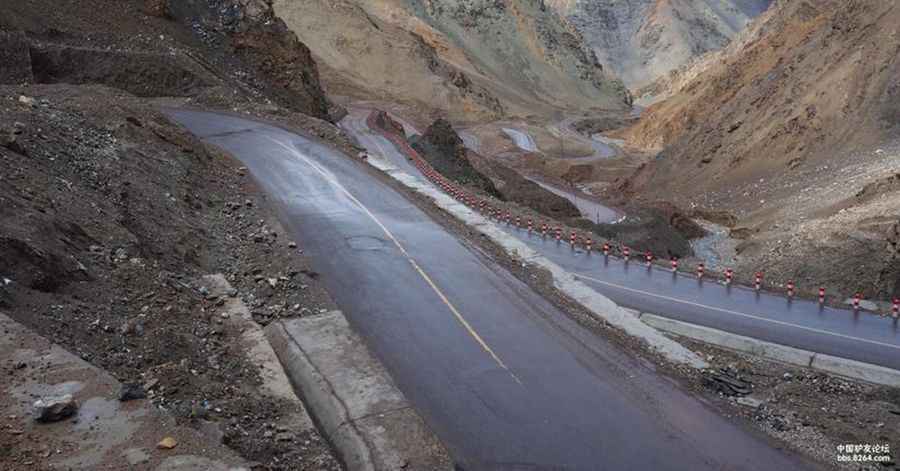
Expect many stretches with no water or food for tens or hundreds of kilometres, dozens of high passes, no shower or even a wash for weeks, and nighttime temperatures of -25 degrees C or lower. For miles and miles it’ll be difficult to see a single other soul. Make sure you have enough petrol, because there are hardly any gas stations along this stretch. Welcome to the 219; Not an Easy Road, in fact probably one of the most challenging roads in the world, but at the same time one of the best and most rewarding. Along the Xinjiang-Tibet Highway there is a lot of military presence. Every person passing through is required to report their passport at the military police. Be aware that the situation can change any time - be careful anyway.
When was China National Highway 219 built?
Construction of this road started in 1951. It was completed in 1957 and fully paved with asphalt in 2013 for all its length. The road, also known as the "Sky Road" in Chinese, passes through disputed area of Aksai Chin, an area administered by the People's Republic of China but also claimed by India, and its construction was one of the triggers for the Sino-Indian War of 1962.
What’s the highest elevation on the China National Highway 219?
Travelers are known to have to wear oxygen masks during this stretch, to deal with altitude sickness. The road tops out at 5.394m (17,696ft) above sea level. The road is long and arduous and crosses several mountain passes of 5,000, 4,000 and 3,000 meters:
| Soge La | 4.732m (15,524ft) | Gänja La | 4.775m (15,666ft) |
| Sancam La | 5.198m (17,053ft) | Kudi Daban | 3.312m (10,866ft) |
| Koshbel Duban | 4.279m (14,038ft) | Sha Zi La | 4.717m (15,475ft) |
| Cha Cang La | 4.810m (15,780ft) | Jerko La | 4.832m (15,853ft) |
| Lame La | 4.832m (15,853ft) | Sing La | 4.914m (16,122ft) |
| Jie La | 4.936m (16,194ft) | Kirgizjangal Pass | 4.950m (16,240ft) |
| Sobiya La | 5.084m (16,679ft) | Chiragsaldi Pass | 4,980m (16,338ft) |
| Daoda top | 5.175m (16,978ft) | Kura La | 5.105m (16,748ft) |
| Tielong Pass | 5.200m (17,060ft) | Mayum La | 5.225m (17,142ft) |
| Shan Da Ban | 5.257m (17,247ft) | Satsum La | 5.350m (17,552ft) |
| Qieshan La | 5.392m (17,690ft) |
Is China National Highway 219 remote?
This road passes through remote areas, so you need to be prepared. Despite its reputation for running through terrain that is by and large uninhabited, the G219 does pass through a number of important historical and religious sites. Perched more than 5,000 meters above sea level, the terrain here is harsh, and there are few signs of life, other than the odd Tibetan antelope, wolf or other wild animal. In recent years, the region has been witness to a number of violent attacks arising from tensions in the region. To travel along the highway is to get a glimpse of places unlike any others in the world. Yet intrepid travelers are not dissuaded, for to travel along the highway is to get a glimpse of places unlike any others in the world. Those who take the G219 are usually the ones who inhabit a spirit of adventure.
When is the best time to drive China National Highway 219?
For your safety, be sure to check the weather forecast before you begin your trip. The extremely high altitude of Tibet makes the winter seasons extremely harsh, marked by extreme cold with gust of strong winds, blowing almost all the time. Therefore it is better to avoid any trip to Tibet during winter. Half of the roads remain closed due to heavy snowfall. The atmosphere becomes extremely arid and almost intolerable. Even in summer you can confront with snowy days. Temperatures here in the winter are brutally cold. There are truck stops along the way, about a day’s travel apart, but it’s wise to bring food and a sleeping bag. A tent can be useful in emergencies. Monsoon always begins from July and end up with August. It rains a lot during Monsoon time and it makes self-driving travel difficult to handle with. And remember, in China, a lot of websites are censored so you won’t be able to access any url you want (especially if Tibet is mentioned).
Pic: http://www.8264.com/youji/2221425.html