How to drive the 62-hairpin turns to Boi La in Tibet?
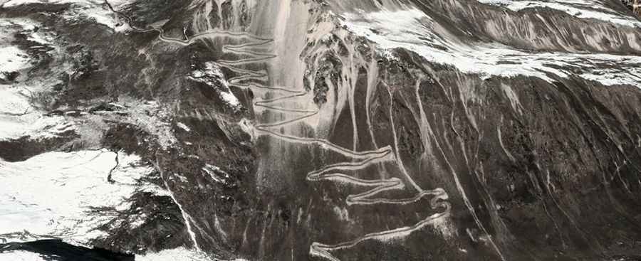
Boi La is a high mountain pass at an elevation of 4,950 meters (16,240 ft) above sea level, located in Cona County, Tibet. The road to the summit is a raw, unpaved track through a series of 62 sharp hairpin turns.
Where is Boi La located?
The pass is situated in the southern part of Tibet, within Cona County of the Shannan Prefecture, in the Himalayas, close to the international border. This is a high-security zone with no cell service, no gas stations, and no permanent residents along the entire track.
Is the road to Boi La unpaved?
The road is entirely unpaved and consists of loose gravel, Himalayan dust, and sharp rocks. The track is exceptionally narrow, often just wide enough for a single vehicle, with vertical drops and zero safety barriers throughout the 62 switchbacks. The surface is unstable, and during the snowmelt season, the ground can become soft and slippery.
How long is the road to Boi La?
The road to the summit is 15.97 kilometers (9.92 miles) long starting from the small settlement of Shemucun. Driving this route involves an elevation gain of 1,401 meters. At nearly 5,000 meters, the lack of oxygen and the steep 8.77% average gradient require a high-clearance 4x4 and a vehicle in perfect mechanical condition.
Is the road to Boi La open in winter?
Set high in the Himalaya, the pass is buried under deep snow and ice for most of the year, making it completely impassable. Even in summer, sudden blizzards can occur.
Road suggested by: Hugh Wilson