Driving Xuechao Pass: The high-altitude heart of the Baojin Line
Reaching an elevation of 3,707m (12,162ft) above sea level on the border between Xiaojin County and Kangding, Xuechao Pass is the technical centerpiece of the Baojin Line. Known among Chinese off-roaders as the "Sichuan version of the Duku Highway," this 133 km route connects Baoxing to Xiaojin through a landscape of extreme verticality. It is a journey where the pavement eventually gives way to raw pastoral tracks, screening out casual tourists and leaving the mountains to real adventurers.
| Road facts: Xuechao Pass (Baojin Line) | |
|---|---|
| Location | Sichuan, China (Xiaojin to Kangding) |
| Elevation | 3,707 m (12,162 ft) |
| Distance | 133 km (Total Baojin Line) |
| Surface | Paved & Unpaved Pastoral Roads |
| Signal | Zero signal for dozens of kilometers |
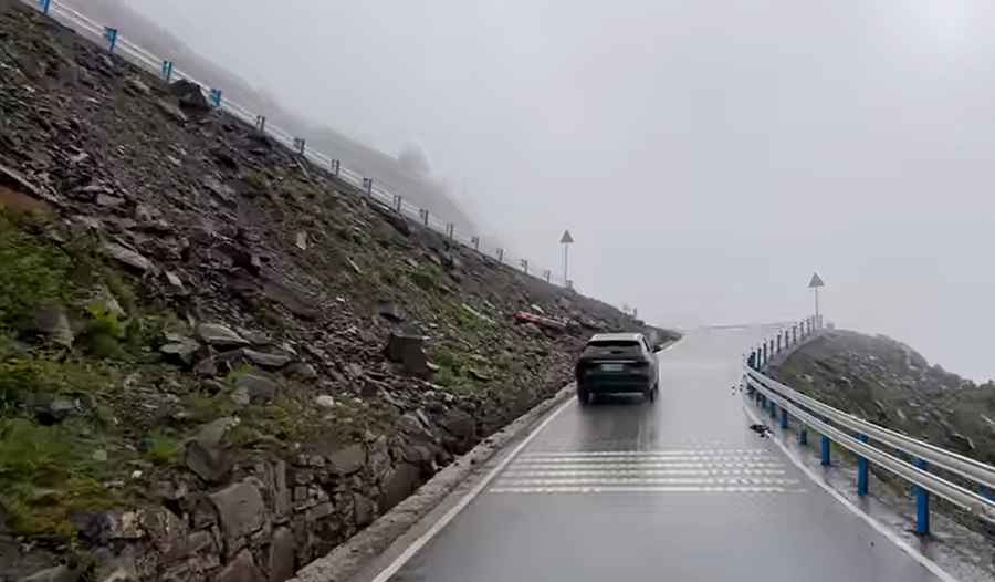
How challenging are the road conditions on the Xuechao Pass?
The transit through Xuechao Pass is a game of two halves. Starting from Baoxing County, the road begins with smooth pavement through Longdong Town. However, after passing Zhonggang Village, the infrastructure deteriorates rapidly. The road transforms into a grueling stretch of unpaved pastoral tracks where loose gravel and deep ruts become the norm. This sector is a brutal test for any vehicle's suspension and tire integrity. A high-clearance 4x4 SUV is not just recommended; it is mandatory to survive the jagged rocks and oxygen-deficient ramps that lead to the summit at coordinates 30.694167, 102.476389.
What are the hazards of the Baojin Line crossing?
The primary risks on the Xuechao Pass are rockslides and persistent high-altitude fog. As seen in recent transits, the road is carved into steep, unstable mountain faces where rain can trigger immediate debris flows. The summit area is frequently shrouded in a thick mist that reduces visibility to a few meters, making the numerous sharp bends and steep drop-offs extremely treacherous. Furthermore, the stretch between Zhonggang Village and Meiwo Township is a dead zone with zero mobile signal for dozens of kilometers. If you have a mechanical failure or a tire puncture here, you are completely on your own in a high-altitude wilderness.
Why is the Xuechao Pass considered a test for experienced drivers?
In the off-road community, crossing the Baojin Line is seen as a rite of passage. Beyond the technical difficulty of the bumpy gravel, the pass sits at an altitude where engines lose significant torque and drivers face the physical toll of thin air. From the Jihong Tibetan Courtyard to the Meiwo Township fork, you are navigating pure pastoral roads shared with livestock and heavy runoff from snow-capped peaks. It is a route that demands pre-set GPS navigation and a vehicle hardened for expedition-level stress. As the locals say: crossing this line is half about the scenery and half about proving your driving skills against the raw geography of Sichuan.
Road suggested by: Hugh Wilson
Pic&video: 中国街景 China Street View