How to drive the unpaved Tiantao Line in the Taihang Mountains?
Tiantao Line, also known as the Taihang Bingchacha, is a mountain cliff road located in the Taihang Mountains, on the boundary between Pingshun County (Shanxi Province) and Linzhou (Henan Province), in China. The track is cut into the limestone walls of the range.
| Road facts: Tiantao Line | |
|---|---|
| Location | Pingshun (Shanxi) to Linzhou (Henan), China |
| Length | 25 km (15.5 miles) |
| Max Elevation | 1,500 m (Yanglaoyan) |
| Surface | Unpaved / Limestone Gravel & Dirt |
What is the route of the Tiantao Line cliff road?
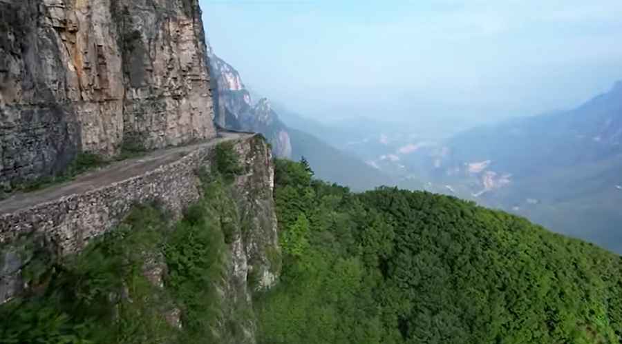
The road spans 25 km (15.5 miles) in length, descending from the mountain sector of Yanglaoyan at 1,500 meters altitude down to Taohuadong Village at 900 meters. The track runs along the inner ledge of the Taihang canyons, connecting the Loess Plateau with the North China Plain basin.
Is the Tiantao Line paved?
The road surface is entirely unpaved, consisting of a single lane of loose limestone gravel, broken rock debris, and dirt. The track follows a shelf-road geometry carved directly into vertical rock faces, featuring vertical drops on the outer edge with no steel guardrails, concrete barriers, or safety walls. Heavy trucks have cut deep ruts into the dirt base along the narrowest sectors.
How does weather affect driving on the Tiantao Line?
The canyon alignment traps moisture, causing high-frequency alpine fog that reduces visibility below ten meters. Rain accumulation converts the dirt track into mud layers, causing tire sideslip on the inclines. Water infiltration triggers spontaneous rockfalls from the overhanging limestone cliffs, blocking the single lane with stone debris.
What are the mechanical requirements for the Tiantao Line?
Vehicles require All-Terrain tires with reinforced sidewalls to resist punctures from the sharp limestone shards. A 4x4 system with a high-clearance undercarriage is necessary to clear the rocky ruts. The 600-meter descent down to Taohuadong requires continuous low gear engagement to utilize engine braking and avoid thermal expansion of the brake fluid.
Are there roadside services on the Tiantao Line?
The 25-kilometer canyon track has no fuel stations, repair garages, or telephone services. Cellular network signals are completely blocked by the vertical rock walls. Drivers must carry mechanical recovery equipment, tire patch kits, and auxiliary fuel containers before exiting the main roads of Pingshun or Linzhou.
Road suggested by: jorge manuel gómez sánchez
Pic: Aerial China