How to drive the Meihan Road through Dawaliangzi Pass?
Dawaliangzi Pass, also known as Dawaliang, is a high-altitude mountain pass at an elevation of 4,597m (15,082ft) above sea level in Xiaojin County, Sichuan Province. The pass is a critical point on the Meihan Road (Meiwo-Hanniu), an 84 km highway that traverses the Mukekeliangzi range at peaks reaching 4,916m. This route was a key post-disaster reconstruction project following the 2008 Wenchuan earthquake, providing a direct tactical link between Meiwo and Hanniu townships that bypasses a previous 110 km detour through Danba County.
| Road facts: Dawaliangzi Pass | |
|---|---|
| Location | Xiaojin County, Sichuan (China) |
| Elevation | 4,597 m (15,082 ft) |
| Highway Standard | Class IV (Mountainous terrain) |
| Pavement Width | 4.0 meters (13.1 ft) |
| Elevation Gain/Loss | +2,484 m / -2,840 m |
What are the technical specifications of the Meihan Road?
The Meihan Road is engineered to Class IV highway standards specifically for mountainous terrain. Logistically, this translates to a very narrow infrastructure: the roadbed width is only 4.5 meters, with an effective pavement width of 4.0 meters. This leaves minimal margin for error when passing oncoming traffic or heavy maintenance vehicles. The 51.66 km section between Meiwo and Hanniu is particularly demanding, as it manages a massive elevation gain of 2,484 meters. Drivers must account for the mixed surface conditions, as some sectors remain unpaved due to constant geological shifts and the extreme altitude of the Mukekeliangzi range.
How does the 4,597m altitude affect driving logistics on Dawaliangzi?
At an elevation of 4,597 meters, the Meihan Road enters the "Sky Road" territory where oxygen levels are significantly reduced. Logistically, this requires vehicles in peak mechanical condition. Naturally aspirated engines will experience a severe power drop during the steep ascent. Technically, the braking system is under high stress during the -2,840 m descent towards Gezong Township; the use of low gears and engine braking is mandatory to prevent brake fade on the narrow, winding asphalt and gravel. Drivers should also monitor for localized mudslides, which are a persistent technical hazard in this sector of Sichuan.
What is the historical and safety significance of the Meihan Highway?
The construction of the Meihan Highway was a high-risk logistical operation completed in 2009 as part of the post-earthquake recovery. The project cost the lives of five engineers from Jiangxi Province during a massive mudslide, highlighting the extreme geological instability of the Dawaliangzi Pass area. Logistically, the road is a lifeline that reduced transit times between Xiaojin and Danba significantly. However, because it crosses snow-capped mountains at nearly 5,000 meters, it is subject to immediate closure during winter months or after heavy rainfall. Carrying emergency survival gear and verifying the vehicle's high-altitude cooling efficiency is a necessary protocol before transit.
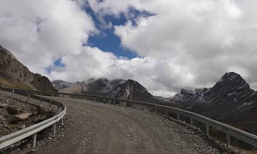
What are the hazards of driving the Meihan Road switchbacks?
The road features numerous tight hairpins and steep inclines to overcome the vertical walls of the Ngawa Prefecture. As seen in the technical layout, the road features metal guardrails in critical sections, but the 4.0m width remains the primary logistical constraint. On the unpaved sectors, traction can be inconsistent, especially for 2WD vehicles. A 4x4 vehicle is recommended to manage the loose gravel and potential debris from small-scale rockfalls. During the ascent, drivers must be prepared for "blind" corners where the narrow pavement requires immediate stopping maneuvers if another vehicle is encountered, making high-quality lighting and horn signals technical requirements for safe passage.
Road suggested by: Hugh Wilson
Pic&video: Walk China - Driving Channel