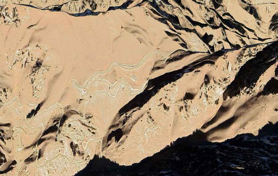
How to drive the 26 hairpins of the Kuteruk Pass?
Kuteruk Pass (also transcribed as Kuteerke) is a mountain pass at an elevation of 3,365m (11,040ft) above sea level, located in the Kunlun Mountains of Kargilik County, Xinjiang, China. The route runs through the Kashgar Prefecture, connecting the western settlement of Xikebande with Suluge Azi to the east.
| Road facts: Kuteruk Pass | |
|---|---|
| Location | Kargilik County, Xinjiang, China |
| Elevation | 3,365 m (11,040 ft) |
| Length | 21.9 km (13.6 miles) |
| Hairpin Turns | 26 |
| Surface | Compacted Gravel |
How long is the road over Kuteruk Pass?
The mountain road is 21.9 km (13.6 miles) long. It climbs from the valley floor near Xikebande, reaches the pass summit at 3,365 meters, and descends the eastern face of the mountain toward Suluge Azi. The track cuts into the dry earth walls of the Kunlun range.
What is the road surface of Kuteruk Pass?
The road surface consists of a single lane of compacted gravel and dirt. The track features 26 consecutive hairpin turns on the steepest mountain sections. Heavy braking by trucks causes corrugated ridges, or calamina, to develop directly on the gravel surface inside the turns, reducing tire traction during steering maneuvers.
What are the mechanical demands on Kuteruk Pass?
At 3,365 meters altitude, engines experience a loss of power due to the lower density of oxygen. Low gear selection is required to maintain momentum up the steep ramps connecting the 26 switchbacks. Due to the low-speed climbing required under high engine loads, radiators operate at high temperatures, requiring drivers to track the coolant gauge during the 21.9-kilometer ascent.
How to drive the descent of Kuteruk Pass?
The descent toward Suluge Azi consists of continuous downward slopes over loose stone layers. Relying solely on the service brakes causes thermal buildup and brake pad fade. Drivers must engage low gears to utilize engine braking across the descent. The 26 hairpin turns require a wide turning radius to prevent the vehicle's tires from slipping sideways into the loose dirt shoulders.
Are there roadside services at Kuteruk Pass?
The 21.9 km mountain sector through Kargilik County has no fuel stations, mechanical repair shops, or cellular network coverage. The steep layout increases fuel consumption compared to driving on flat surfaces. Vehicles must carry a full-size spare tire, tire changing tools, and water supplies before departing Xikebande.
Road suggested by: Hugh Wilson