Road to Kuribankasi Daban: Driving the 4,267m Military Track in Xinjiang
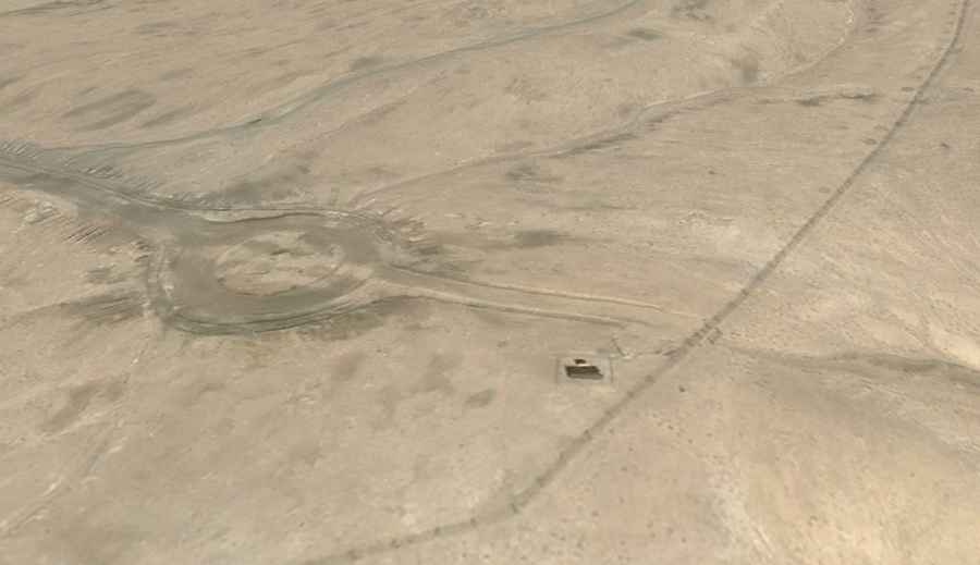
Located in Akto County, within the Kizilsu Kyrgyz Autonomous Prefecture of Xinjiang, China, Kuribankasi Daban (also known as Aghbai Budabel) is a high-altitude mountain pass reaching an elevation of 4,267m (13,999ft) above sea level. The pass is situated in the Pamir mountain range and serves as a military access route, with a permanent military installation located at the summit.
| Road facts: Kuribankasi Daban | |
|---|---|
| Location | Akto County, Xinjiang, China |
| Elevation | 4,267 m (13,999 ft) |
| Length | 11.1 km (6.89 miles) |
| Average Gradient | 1.65% (General) / 9.31% (Final Section) |
| Coordinates | 38.581944, 74.069250 |
| Surface | Unpaved / Hard-packed dirt |
How is the road to Kuribankasi Daban?
The road starting from Kerege Tashi to the summit is 11.1 km (6.89 miles) long. Unlike traditional alpine tracks, this route is exceptionally straight despite the rugged topography, indicating a direct vertical ascent approach. The track is entirely unpaved, consisting of hard-packed dirt and loose stones typical of the Pamir plateau. Over the 11.1 km stretch, the elevation gain is 184 meters, but the final approach to the 4,267m peak features a sustained average gradient of 9.31%, requiring constant torque and high-altitude engine management.
What are the technical hazards of the Kuribankasi Daban military road?
The primary hazard is the extreme altitude of 4,267m, where atmospheric pressure is significantly lower than at sea level. This results in an oxygen-depleted environment that affects both driver cognition and engine combustion. A 4WD vehicle with a reliable cooling system is mandatory, as low-gear climbing at this altitude puts excessive thermal load on the motor. The straight nature of the road can also be deceptive; despite the lack of curves, the 9.31% gradient on an unpaved surface requires careful throttle control to prevent wheel spin on the loose top layer.
Is Kuribankasi Daban accessible to the public?
Due to the military base located at the summit, access to Kuribankasi Daban is strictly regulated and often restricted to authorized military personnel. The road is a vital logistics link for border security in the Xinjiang region. The pass is impassable for the majority of the year due to heavy snow and permafrost. Even during the short summer window, sub-zero temperatures and sudden blizzards are frequent. There are no civilian services, refueling points, or emergency facilities available within the entire sector.
What is the driving strategy for the 4,267m ascent?
Navigating this 11.1 km track requires a vehicle in perfect mechanical condition. High-altitude power loss can reach up to 40% in naturally aspirated engines, making turbocharged diesel engines preferable. On the descent, engine braking must be utilized to manage the 9.31% slope, as the straight track may tempt higher speeds that can lead to brake overheating. Drivers must be prepared for self-recovery and carry essential cold-weather gear, as the military nature of the summit means unauthorized civilian presence is not permitted for long periods.
Road suggested by: Hugh Wilson