Road to Oibalegen Pass: Driving the 4,624m Border Track in Xinjiang
Located in Akto County, within the Kizilsu Kyrgyz Autonomous Prefecture of Xinjiang, China, Oibalegen Pass is a high-altitude mountain pass reaching an elevation of 4,624m (15,170ft) above sea level. Situated near the Gorno-Badakhshan Autonomous Province of Tajikistan, the route is a critical unpaved road connecting the remote settlement of Chongrang with the international border.
| Road facts: Oibalegen Pass | |
|---|---|
| Location | Akto County, Xinjiang, China |
| Elevation | 4,624 m (15,170 ft) |
| Length | 42.9 km (26.6 miles) |
| Coordinates | 38.653333, 74.232222 |
| Surface | Unpaved / Primitive Track |
How is the road to Oibalegen Pass?
The road to Oibalegen Pass is a 42.9 km (26.6 miles) unpaved track running in a north-south direction. The route is characterized by significant elevation changes, including a 493-meter ascent and a 1,046-meter descent depending on the direction of travel. The surface is a primitive mountain trail composed of loose scree, sand, and high-altitude permafrost debris. Due to the extreme environment and the lack of maintenance infrastructure, a heavy-duty 4x4 vehicle is mandatory for any attempt to cross the pass.
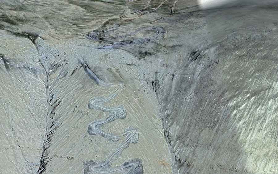
How many hairpin turns are on the Oibalegen Pass southern access?
The southern approach toward the Tajikistan border is the most technical section of the route, featuring 19 sharp hairpin turns concentrated near the summit. These switchbacks are designed to manage the steep gradients of the Pamir mountain range. The turns are narrow and unbanked, with significant exposure to vertical drops and no safety barriers. Maneuvering through these 19 hairpins requires low-speed precision and constant monitoring of tire traction on the loose, high-altitude surface.
What are the mechanical hazards at 4,624m?
At an elevation of 4,624 meters, the primary mechanical hazard is power loss due to thin air. Naturally aspirated engines will experience a significant drop in performance, making low-range gearing essential for the climb. The cooling system must be in optimal condition, as the reduced atmospheric pressure lowers the boiling point of the coolant. Additionally, the route is impassable for the majority of the year due to deep snow and extreme sub-zero temperatures. Even in summer, the track can be blocked by sudden snowstorms or landslides caused by permafrost melting.
What is the driving strategy for the Oibalegen Pass crossing?
Driving the 42.9 km stretch requires full self-sufficiency. It is necessary to carry extra fuel, recovery gear, and oxygen supplies due to the risk of altitude sickness. On the 1,046-meter descent, engine braking is the only reliable method to control vehicle speed; over-reliance on the foot brake at this altitude will lead to overheating and mechanical failure. Before starting the transit from Chongrang, drivers must verify all vehicle fluids and tire pressure, as there are no refueling, repair, or emergency services available in this restricted border zone of Xinjiang.
Road suggested by: Hugh Wilson