Anwu La Pass: Crossing the high-altitude G317 in Northern Tibet
Anwu La, also known as Angu La or Angwu La, is a high mountain pass at an elevation of 4,602 meters (15,098 ft) above sea level, located in the Nagqu prefecture of the Tibet Autonomous Region. Situated on the China National Highway 317 (G317), the pass is a critical logistical link between Baqen and Zaqu. While the road is totally paved, the physical reality of driving at 4,600 meters involves managing extreme oxygen deprivation for the internal combustion engine and navigating high-altitude plateaus where road conditions can shift from clean asphalt to treacherous ice in minutes.
| Road facts: Anwu La Pass (G317) | |
|---|---|
| Location | Nagqu, Tibet, China |
| Elevation (Actual) | 4,602m (15,098ft) |
| Length | 36 km (22 miles) |
| Technical Hazard | Hidden ice / Power loss (thin air) |
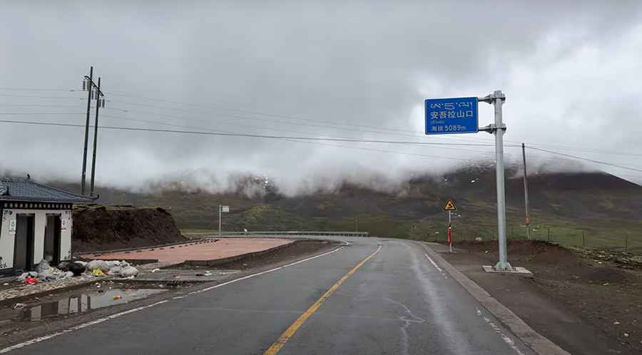
Why is the elevation sign at Anwu La summit incorrect?
At the summit of Anwu La, drivers will encounter a formal traffic sign indicating an elevation of 5,089 meters. However, GPS measurements and topographic data confirm the actual elevation is closer to 4,602 meters. This discrepancy of nearly 500 meters is a significant logistical factor for travelers monitoring altitude sickness or vehicle performance. Whether due to outdated survey methods or a geographical error, relying on the sign can lead to incorrect expectations regarding engine cooling and aspiration needs. For a driver, the 4,602m mark still represents a zone where a naturally aspirated motor will lose approximately 40% of its sea-level power.
How challenging is the 36km drive between Baqen and Zaqu?
The 36-kilometer section of the G317 through Anwu La is characterized by long, sustained high-altitude transits rather than sharp, technical hairpins. However, the logistical challenge lies in the "hidden ice" (black ice) that forms on the asphalt during the night and stays in shaded sectors. The road condition is generally paved, but ongoing maintenance and repairs are a constant reality in Nagqu due to the permafrost's impact on the sub-surface. Maintaining a stable speed is not just about safety, but about managing the thermal load on the motor while climbing through the oxygen-starved plateau air.
What are the winter hazards on the G317 in Northern Tibet?
In winter, the Anwu La Pass is a high-risk sector. Despite being paved, the G317 is frequently swept by heavy snow and high-velocity winds that create drifts across the road. The high-altitude grasslands offer no protection from the elements, and visibility can drop to zero during a blizzard. The presence of snow-capped mountains nearby ensures that the asphalt temperature remains near freezing, making any moisture on the road a potential hazard. Drivers must be prepared for total isolation between Baqen and Zaqu, as recovery services in Northern Tibet are limited and emergency response is hindered by the extreme geography.
What mechanical prep is needed for the 4,602m Nagqu crossing?
Before entering the G317 high-altitude sectors, verify that your vehicle's air intake system is clean; at 4,600 meters, any restriction in air flow will cause the engine to struggle significantly more than usual. Check your battery and alternator, as sub-zero temperatures are common even in the shoulder seasons. Ensure your tires are rated for cold temperatures and carry chains, as a sudden snow squall can turn the paved surface into a friction-less track. Carry extra fuel and water, as fuel consumption increases on high-altitude climbs. In this part of Tibet, the reliability of your electrical and cooling systems is your only safety net against the hostile environment of the Nagqu plateau.
Road suggested by: Hugh Wilson
Pic&video: 中国街景 China Street View