Aryktoryk Pass: Driving the High-Altitude Border Road in Xinjiang
Aryktoryk Pass is a high mountain pass at an elevation of 3,468 meters (11,377 feet) above sea level, located in Wuqia County, in Xinjiang, China.
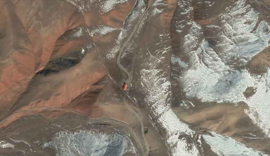
| Road facts: Aryktoryk Pass | |
|---|---|
| Location | Xinjiang, China (near Kyrgyzstan border) |
| Elevation | 3,468 m (11,377 ft) |
| Length | 14 km (8.7 miles) |
| Surface | Unpaved / Gravel |
| Vehicle Required | High-clearance 4x4 |
Where is Aryktoryk Pass?
The pass, also known as Are Ketuo Rukehe, is located within the Kizilsu Kyrgyz Autonomous Prefecture, in the westernmost part of the country, near the international border with Kyrgyzstan. The area is a sensitive border zone with no mobile coverage, no gas stations, and no repair services.
How long is the road through Aryktoryk Pass?
The road is 14 km (8.7 miles) long and runs north-south, connecting the settlements of Kuoputamu and Juelege Mantala. The track follows the natural contours of the Pamir mountain ranges, featuring constant elevation changes and sharp turns that require low speeds to maintain control on the loose gravel.
Is the road to Aryktoryk Pass unpaved?
The entire 14 km stretch is unpaved. The surface consists of packed dirt and loose stones. The track includes several narrow sections where passing another vehicle is difficult, and steep ramps that test engine power at over 3,000 meters. A high-clearance 4x4 vehicle is required. There are no safety barriers or guardrails along the exposed edges.
Is the road to Aryktoryk Pass open year-round?
In winter, the pass is completely blocked by heavy snow and extreme temperatures, making it impassable from October to May. It can become unstable during the spring thaw or after heavy rain.
What is the access status of the pass?
Because of its proximity to the Kyrgyzstan border, the area is under strict military control. Travelers may encounter checkpoints where permits and identification are required. Public access can be restricted without notice due to security operations or border drills.
Road suggested by: Hugh Wilson