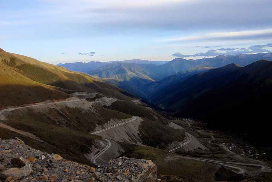
Driving the Jiu Ruo Road to Lamaling Shankou: 1,000 curves in the Minshan Mountains
Lamaling Shankou is a high mountain pass at an elevation of 3,993 meters (13,100 ft) above sea level, located on the boundary between Zoigê and Jiuzhaigou counties, within the Ngawa Tibetan and Qiang Autonomous Prefecture of Sichuan Province, China. The pass cuts through the limestone ridges of the Minshan mountain range via a fully paved regional road.
| Road facts: Lamaling Shankou (Jiu Ruo Road) | |
|---|---|
| Location | Zoigê - Jiuzhaigou, Sichuan (China) |
| Elevation | 3,993 m (13,100 ft) |
| Length | 50.8 km (31.5 miles) |
| Curves | Over 1,000 turns |
| Surface | Paved |
How long is the Jiu Ruo Road to Lamaling Shankou?
The mountain road, designated as the Jiu Ruo Road, spans 50.8 kilometers (31.5 miles), running north-south to connect the localities of Qiujixiang and Zaijiu. The entirely asphalted route serves as a high-altitude connection through the northern mountain sectors of Sichuan. Due to the tight configuration of the terrain, the 50.8-kilometer transit requires between 2 and 3 hours of continuous low-speed driving.
What are the hazards on the 1,000 curves of Lamaling Shankou?
The primary driving characteristic of the route is its layout, featuring more than 1,000 continuous curves and sharp hairpins stacked closely together along the steep limestone slopes. The asphalted lane traces high cliff sides where lateral concrete barriers are missing or damaged in several sections. The mountain flanks are geologically unstable, making the road highly prone to sudden rockfalls and debris accumulation triggered by local seismic movements or heavy summer rainstorms that reduce tire grip.
Is the road to Lamaling Shankou open in winter?
At an altitude approaching 4,000 meters, the pass faces severe mountain winters with heavy snowfall and extensive sheets of black ice blocking the asphalted surface from November until late April. The route remains subject to sudden high-altitude fog blankets that reduce visibility down to zero along the switchbacks. During freeze cycles, vehicles require winter snow chains to climb the sustained gradients and to maintain traction during the continuous braking required on the descent toward Zaijiu.
Road suggested by: Hugh Wilson
Pic: 怡弄