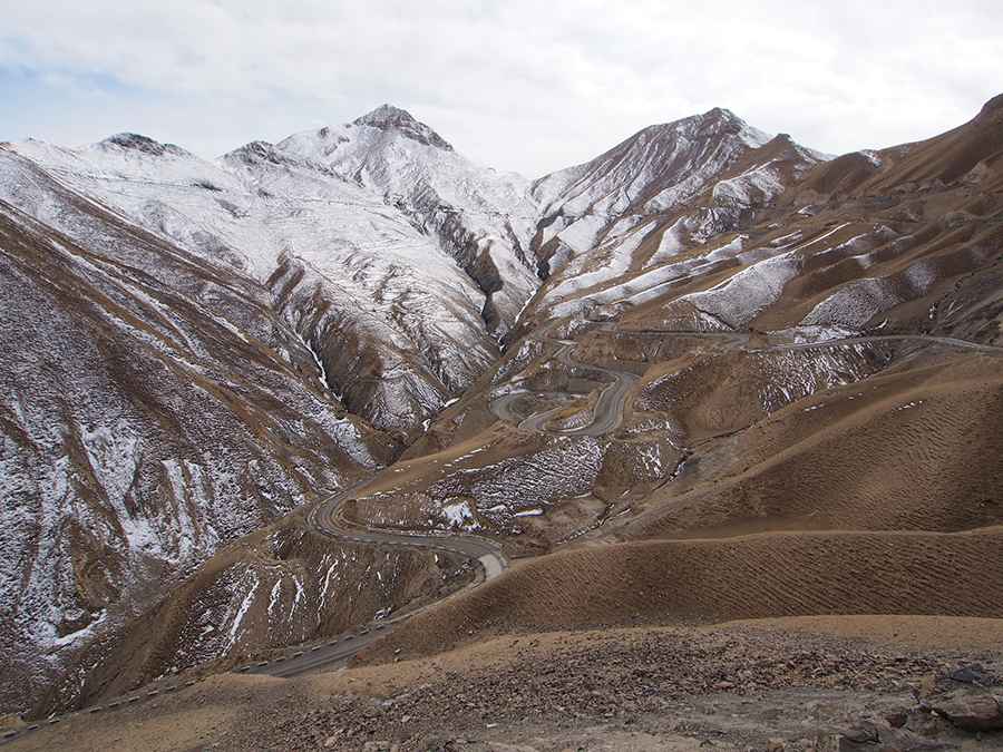
How dangerous is the road with 60 hairpins to Teganaqik Pass in Xinjiang?
Teganaqik Pass is a high mountain crossing reaching an elevation of 3,778m (12,395ft) above sea level in Akto County, within the Xinjiang region of China. Tucked away in the Kizilsu Kyrgyz Autonomous Prefecture, the road over this pass is a relentless zig-zag carved into a barren, rocky landscape. It is a world of 60 tight hairpin turns where the air is thin, the drops are unprotected, and the mechanical endurance of your vehicle is tested at every single bend of the 46-kilometer journey.
| Road facts: Teganaqik Pass | |
|---|---|
| Location | Akto County, Xinjiang (China) |
| Elevation | 3,778 m (12,395 ft) |
| Length | 46.4 km (28.8 miles) |
| Hairpin Turns | 60 extreme bends |
| Surface | Unpaved / Gravel / Occasional Concrete |
How long is the 60-hairpin climb to Teganaqik Pass?
The road through the pass stretches for 46.4 km (28.8 miles), connecting Aiqi Kuoyuzi Agezi in the south with the Poke Tao'aige Zi Brigade in the north. This is a slow-motion drive where you spend more time steering through hairpins than driving in a straight line. With 60 hairpins packed into the steep sections, the ascent is a constant battle for momentum. At nearly 3,800 meters, your engine will lose a massive amount of power; if you don't manage your gears correctly, the car will struggle to pull through the tightest turns, especially on the unpaved sections where the tires fight for grip on the loose gravel.
What are the road conditions on Teganaqik Pass?
The surface of Teganaqik Pass is primarily unpaved, with some concrete patches that are often broken by the extreme freeze-thaw cycles of the Xinjiang mountains. As seen in the Kizilsu region, the track is carved directly into the crumbling mountain face. There are no guardrails to stop a vehicle from sliding off the edge, and the road is barely wide enough for two cars to pass in many sections. The terrain is a vast, brownish desert of rocks where falling debris is a constant risk after heavy rain or snow. It is a primitive route where the dust kicked up by your wheels can hide deep ruts that will easily damage a standard car's oil pan.
Why is the descent from Teganaqik Pass a test for brakes?
The 46.4 km journey involves massive elevation changes that will punish your braking system. On the long, steep descents following the 60 hairpins, relying only on your foot brake will lead to overheating and total brake failure. It is mandatory to drive in a low gear to let the engine hold the weight of the car back. The turns are so sharp and frequent that there is very little time for the rotors to cool down between applications. For any driver, the physical demand of steering through sixty consecutive hairpins at high altitude is exhausting, and a loss of concentration for just one second can lead to a long drop down the unprotected mountainside.
When can you drive through Teganaqik Pass safely?
Due to its elevation of 3,778 meters, Teganaqik Pass is subject to brutal mountain weather year-round. Sudden snowstorms can hit even in the summer, turning the unpaved surface into a lethal slurry of mud and slush. Before attempting the 60 hairpins, you must check the local Xinjiang weather reports; once you are committed to the climb, there are no turn-around points for several miles. In winter, the pass is often buried under deep snow and ice, making it impassable for anything other than heavy-duty machinery. Always carry extra fuel and warm gear, as cell signal in Akto County is non-existent once you leave the valley floor.
Road suggested by: Hugh Wilson
Pic: Chen Huang