How to drive the high-altitude road from Tinizi to Bianlongduo?
The road from Tinizi to Bianlongduo is a high-altitude technical track located in Xaitongmoin County, within the Xigazê prefecture of the Tibet Autonomous Region, China. Spanning 20.4 km (12.67 miles), this north-south corridor is a critical logistical challenge, as it requires crossing two extreme mountain passes: Sera La at 5,305m and Chesang La at 5,362m.
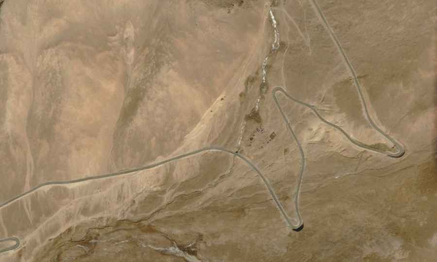
| Road facts: Tinizi to Bianlongduo | |
|---|---|
| Location | Xaitongmoin, Xigazê, Tibet, China |
| Max Elevation | 5,362 m (17,591 ft) |
| Length | 20.4 km (12.67 miles) |
| Hairpin Turns | 29 |
| Surface | Unpaved / Loose Gravel / High-Clearance 4x4 Required |
What is the technical condition of the road from Tinizi to Bianlongduo?
The 20.4 km transit is characterized by a primitive unpaved surface consisting of loose gravel and sedimentary rock. Technically, the road is a high-load environment featuring 29 sharp hairpin turns that demand constant steering correction. Logistically, attempting this route without a high-clearance 4x4 vehicle is a high-risk operation due to deep ruts and the lack of drainage infrastructure. The steep sections between the two passes—Sera La and Chesang La—require precise gear selection to manage engine torque in an oxygen-depleted environment at over 5,300m altitude.
How to navigate the 29 hairpins of the Sera La and Chesang La passes?
Driving the 20.4 km from Tinizi to Bianlongduo requires advanced technical concentration. The 29 hairpins are tight and often lack safety berms, with significant exposure to vertical drops. Technically, the high-altitude transit (topping out at 5,362m) causes internal combustion engines to lose approximately 40-50% of their power. Logistically, this means drivers must maintain a steady momentum and avoid unnecessary stops on the steepest ramps. The surface integrity is highly unstable; localized rockfall from the surrounding peaks is a constant technical hazard that can obstruct the narrow track without warning.
Is the road between Tinizi and Bianlongduo open year-round?
Logistically, this sector of Xaitongmoin County is inaccessible for most of the year. The road is typically blocked by heavy snow and ice from late October until late June or early July. Technically, even during the short summer window, rapid weather shifts can drop temperatures below freezing, turning the unpaved surface into a high-risk mud channel. Drivers must implement a strict safety protocol, including carrying supplementary oxygen for Acute Mountain Sickness (AMS) and ensuring the vehicle's cooling and braking systems are audited for high-altitude performance before departing from Tinizi.
Vehicle requirements and logistical self-sufficiency in Xigazê
The technical isolation of the Tinizi-Bianlongduo corridor means there is zero mechanical or medical support available on the 20.4 km stretch. Logistically, a vehicle must be equipped with All-Terrain tires and at least one full-size spare. The high-altitude transit across two 5,300m+ passes puts extreme stress on tire pressure logistics and suspension components. It is mandatory to verify fuel reserves, as the increased fuel consumption caused by the steep 29 hairpins and thin air can significantly reduce the vehicle's operational range. This route is a technical continuation of the regional network, often linked by drivers exploring the nearby Lungzang La area.
Road suggested by: Hugh Wilson