Rathi La: Driving the high-altitude paved road in Batang
Rathi La is a high mountain pass at an elevation of 4.689m (15,383ft) above sea level, located in Sichuan, in China.
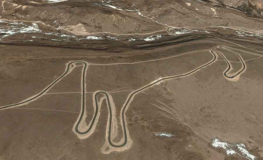
| Road facts: Rathi La (Rato La) | |
|---|---|
| Elevation | 4,689m (15,383ft) |
| Length | 48.5 km (30.1 miles) |
| Max Gradient | 13% |
| Surface | Mostly Paved (Asphalt) |
| Location | Bomixiang to Zhangna (Sichuan) |
Where is Rathi La?
The pass, also known as Rato La, is located in Batang County, within the Garzê Tibetan Autonomous Prefecture, in western Sichuan. The pass offers direct views of the Genyen mountains, one of the most sacred and remote ranges in Tibet. The road serves as a gateway for those exploring the deep valleys between Batang and Litang.
When was the road through Rathi La built?
The road through the pass was built in the 2010’s. It provides access to the remote highlands near the Genyen Massif. Although it is now mostly paved, the drive remains a serious challenge due to the extreme altitude and the nature of the road, with hundreds of tight turns and steep sections.
Is the road to Rathi La paved?
The road to the summit is mostly paved with asphalt, but its condition can vary depending on recent weather events. Despite the pavement, the road is very steep, with some ramps hitting a 13% maximum gradient. Drivers should expect hundreds of hairpin turns as the road climbs quickly into the high alpine zone.
How long is the road to Rathi La?
The drive is 48.5 km long, connecting Bomixiang in Batang County with Zhangna in Litang County.
What are the main hazards when driving Rathi La?
The primary hazard is the extreme altitude. At nearly 4,700 meters, there is a notorious absence of oxygen which can affect both the driver's focus and the vehicle's engine power. The weather is also a critical factor; sudden snowfalls and freezing temperatures are common even during the summer months.
Road suggested by: Hugh Wilson