How to drive to Chugyu La in the Qomolangma National Nature Preserve?
Chugyu La is a high mountain pass at an elevation of 4,415m (14,484ft) above sea level, located in Tingri County, within the Xigazê Prefecture of the Tibet Autonomous Region, China.
Where is Chugyu La?
The pass is situated in a trans-Himalayan position, set between the glacial valleys of the Bum Chu and Kharda Chu rivers. It lies within the protected area of the Qomolangma National Nature Preserve, south of the main G318 Friendship Highway.
🇨🇳 Chugyu La Technical Data
| Elevation | 4,415m (14,484ft) |
| Max Gradient | 25% |
| Distance | 17.1 km (10.6 miles) |
| Location | 28.30672, 87.4205 |
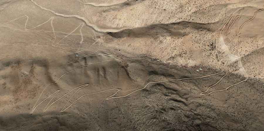
Is the road to Chugyu La unpaved?
The road to the summit is a rugged, totally unpaved mountain track. It is characterized by its extreme steepness, with several ramps reaching a maximum gradient of 25%. Due to the loose gravel surface and the significant incline, a high-clearance 4x4 vehicle with a powerful engine is mandatory to navigate the ascent safely.
How long is the road to Chugyu La?
The road is 17.1 km (10.62 miles) long, running in a south-north direction. It connects the settlements of Kedong and Chicun. The drive is slow-going due to the technical nature of the terrain and the high altitude, which affects both vehicle oxygen intake and driver stamina.
Can you see Mount Everest from Chugyu La?
Yes, the summit of Chugyu La offers one of the most dramatic panoramic views in the region. On clear days, Mount Everest (Qomolangma) is clearly visible to the south, along with other major peaks of the Himalayas. The pass provides a unique vantage point of the massive North Face of the Everest massif and the surrounding glaciers.
Road suggested by: Hugh Wilson