Driving the extreme Tiankong Xian road to Hongpinshan and Tianhedong Daban
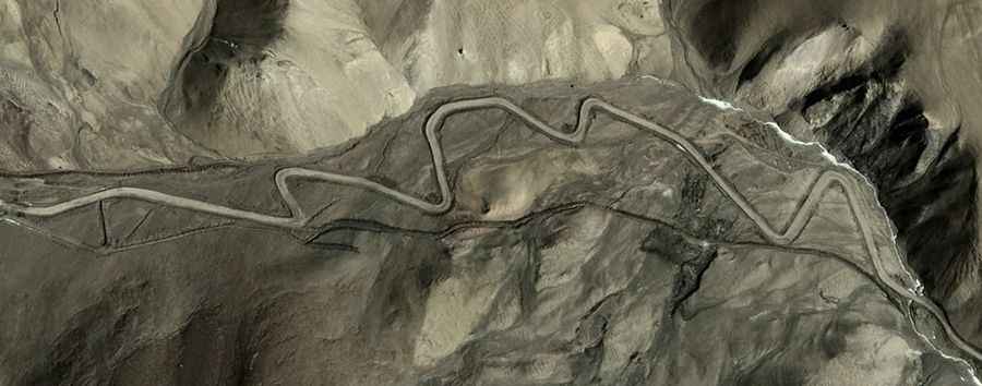
The Tiankong Xian is a high-altitude military and logistical road located in the southwestern part of the Hotan Prefecture, within the Xinjiang Autonomous Region of China. This 69.2 km (43 miles) corridor is officially one of the highest roads in the country, crossing several passes exceeding 5,400 meters above sea level.
| Road facts: Tiankong Xian | |
|---|---|
| Location | Hotan Prefecture, Xinjiang (China) |
| Max Elevation | 5,621 m (18,441 ft) - Hongpinshan |
| Length | 69.2 km (43 miles) |
| Max Gradient | 13% |
| Access | Restricted / Closed to foreigners |
Where is the Tiankong Xian road located?
The Tiankong Xian runs south-north for 69.2 km, starting from Heweitan and ending at the junction with the Wuersisan Radome Road. Logistically, this route is a vital strategic link in the Kunlun Mountains, gaining over 1,017 meters of elevation. Technically, the road is situated in a highly sensitive border zone and is strictly closed to foreigners. The transit requires specialized permits and heavy-duty 4x4 vehicles to navigate the extreme thin air and unpredictable terrain of the Xinjiang highlands.
How challenging is the climb to Hongpinshan and Tianhedong Daban?
The Tiankong Xian is a brutal test of mechanical endurance, featuring two of the highest motorable points in the region. The road tops out at Hongpinshan, a high mountain pass at 5,621m (18,441ft), and Tianhedong Daban, which reaches 5,590m (18,339ft). Technically, the gradients along these ramps hit a maximum of 13%. Driving at these elevations causes a significant drop in engine power due to the lack of oxygen, requiring a vehicle with a perfectly maintained cooling and fuel injection system to avoid stalling on the steep, unpaved hairpins.
What are the conditions at Pingtai Mountain on the Tiankong Xian?
As the road climbs toward Pingtai Mountain (Platform Mountain) at 5,454m, the topography becomes exceptionally rugged. Logistically, the "platform" nature of the summit implies a flat but exposed high-altitude plateau where extreme crosswinds are a constant hazard for high-profile vehicles. The 69.2 km transit offers zero services, meaning drivers must be entirely self-sufficient in terms of fuel, oxygen, and thermal gear. The track is subject to rapid weather shifts, where summer snowstorms can turn the 13% ramps into zero-traction zones in a matter of minutes.