How difficult is the steep road to Drongu La in Tibet?
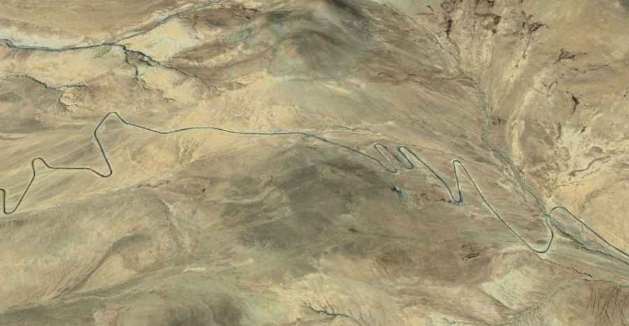
Drongu La is a high-altitude mountain pass reaching an elevation of 4,929m (16,171ft) above sea level in Sa'gya County, part of the Xigazê prefecture in Tibet. While the road over the pass is fully paved, the extreme elevation and the brutal geometry of the terrain make it a high-risk route. Known locally as the Sa Chu Xian, this asphalt track is a masterclass in mountain engineering, but for the driver, it is a constant battle against oxygen depletion and the mechanical strain of one of the steepest paved climbs in the region.
| Road facts: Drongu La | |
|---|---|
| Location | Sa'gya County, Xigazê (Tibet) |
| Elevation | 4,929m (16,171ft) |
| Length | 37.4 km (23.2 miles) |
| Max Gradient | 18% |
| Surface | Paved / Asphalt |
How long is the Sa Chu Xian road over Drongu La?
The drive spans 37.4 km (23.2 miles), running north-south between the settlements of Zhaxigangxiang and Mabujiaxiang. Although the surface is paved, the 37 km journey is a grueling exercise in high-altitude logistics. The road is built to handle the extreme temperature swings of the Tibetan plateau, but the asphalt can become brittle and develop sudden cracks or frost heaves. The climb is relentless, offering views of Mount Everest in the distance, but the driver’s focus must remain on the immediate technical challenges of the road itself rather than the horizon.
What makes the southern side of Drongu La so dangerous?
The southern approach to the 4,929-meter summit is where the real danger lies, with ramps hitting a maximum gradient of 18%. On a paved surface, an 18% incline is exceptionally steep, requiring the engine to work at its absolute limit. At this altitude, air density is roughly 55% of what it is at sea level, meaning your vehicle’s cooling system and torque delivery are under immense pressure. Keeping the car moving upward without overheating the transmission or the engine is a primary concern, especially for heavily loaded vehicles or small-displacement engines common in the region.
Is Drongu La passable in winter?
Winter conditions on Drongu La turn the 18% gradients into a lethal slide. Heavy snowfall and extreme winds frequently block the pass, and while the road is paved, it is not regularly salted or cleared. The asphalt becomes a sheet of black ice, making traction nearly impossible even for 4x4 vehicles. During the colder months, the lack of oxygen is compounded by temperatures that can drop well below -30°C, making any mechanical failure a life-threatening emergency. Always check local weather reports, as storms can move in from the Himalayas with very little warning, trapping drivers on the exposed hairpins.
What should you check before driving the Drongu La pass?
Before attempting the 37.4 km crossing, you must verify the integrity of your braking system. The descent from 4,929 meters down the 18% ramps will put a massive thermal load on your brake pads and discs. Relying solely on the foot brake is a recipe for disaster; you must use heavy engine braking to control the descent. Additionally, check your tire pressure; the change in atmospheric pressure at nearly 5,000 meters can affect tire performance and handling. Carrying extra fuel and oxygen is mandatory, as the physical toll of a simple tire change at this elevation can lead to rapid exhaustion or altitude sickness.
Road suggested by: Hugh Wilson