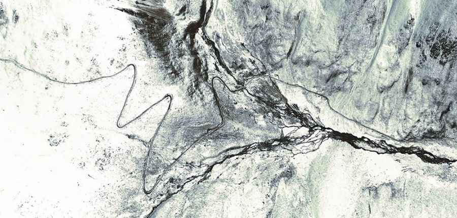
How to drive the 12 hairpin turns of Yepuchen La in Tibet?
Yepuchen La (also known as Yipuqin La) is a high-altitude mountain pass at an elevation of 5,113m (16,774ft) above sea level, located in the eastern Nyenchen Tanglha mountains of Tibet, China. Technically, the pass marks the logistical boundary between Biru County (Nagqu) and Banbar County (Chamdo). Navigating this 33 km unpaved route requires a high-clearance 4x4 vehicle to manage the extreme gradients and the technical series of hairpins near the summit.
| Road facts: Yepuchen La (Yipuqin La) | |
|---|---|
| Location | Nagqu/Chamdo Border, Tibet (China) |
| Elevation | 5,113 m (16,774 ft) |
| Length | 33 km (20.5 miles) from Tsapuka to Yaibug |
| Max Gradient | 13% |
| Surface | Unpaved (Loose gravel and rock) |
What are the technical driving conditions of the Yepuchen La pass?
The 33 km route between Tsapuka and Yaibug is characterized by a demanding geometry. Technically, the ascent features ramps with a maximum gradient of 13%, requiring precise throttle management to maintain traction on the loose unpaved surface. The most critical sector is located near the summit, where 12 sharp hairpin turns demand maximum steering precision and situational awareness. Operating a vehicle at 5,113m also results in a significant reduction in engine torque, making the 4x4 low-range gear essential for the steepest sections.
How to manage logistics near Samu Co and Sepu Kangri?
The road passes to the west of Samu Co lake and offers a direct technical observation point for Sepu Kangri (6,956m). Logistically, this region is subject to rapid alpine weather shifts that can instantly alter the friction levels of the unpaved track. To the southeast, the road follows the Nok Chu valley, where the terrain is prone to landslides and seasonal washouts. Safety protocols mandate total self-sufficiency, as the 33 km transit offers no mechanical or recovery support infrastructure.
Mechanical requirements for the Nyenchen Tanglha mountain transit
Technically, the Yepuchen La transit puts an extreme thermal load on the vehicle’s braking and cooling systems. The 13% descent requires the constant use of engine braking to prevent brake fade. Before initiating the climb, a full inspection of the drivetrain and tire sidewalls is mandatory, as the rocky debris in the Nagqu-Chamdo transition zone is highly abrasive. Given the total absence of refueling points or medical aid, the logistical preparation must include auxiliary fuel and oxygen supplies for the crew to manage the physiological effects of the 5,113m altitude.
Road suggested by: Hugh Wilson