Shangshang La: The technical 24-hairpin unpaved climb in Tibet
Shangshang La is an extreme high-mountain pass at an elevation of 5,228 meters (17,152 ft) above sea level, located in Cona County, within the Shannan Prefecture of the Tibet Autonomous Region. The road through the pass is a technical 30-kilometer unpaved track that connects the settlements of Changda and Jisong. The physical reality of this route involves managing 24 tight hairpin turns on a raw gravel surface where the extreme altitude causes a massive drop in engine torque and the thin air makes cooling the motor a critical logistical challenge.
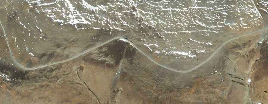
| Road facts: Shangshang La (Cona) | |
|---|---|
| Location | Cona County, Tibet, China |
| Elevation | 5,228m (17,152ft) |
| Length | 30 km (18.6 miles) |
| Hairpin Turns | 24 switchbacks |
How challenging is the 30km climb to Shangshang La?
The 30-kilometer transit over Shangshang La is a high-intensity mechanical test. The unpaved surface is a mix of loose gravel and sharp mountain rocks that require a 4x4 vehicle with high ground clearance. The most technical part of the drive is the sequence of 24 hairpin turns concentrated near the summit. On these "switchbacks," the car's weight shifts constantly on an unstable surface, requiring precise steering and throttle control. At over 5,200 meters, a naturally aspirated motor will lose nearly 40% of its power, making it easy to stall on the steepest turns where the terrain is most aggressive.
What are the hazards of the Changda to Jisong mountain track?
The primary hazard on Shangshang La is the combination of extreme isolation and the total lack of safety infrastructure. The track clings to the Himalayan ridges with steep, unprotected drops and no guard rails. The physical reality of the surface is that it is prone to deep ruts and washouts, especially after sudden snowmelt or summer storms. Meeting oncoming traffic—often heavy local trucks—on the 24 hairpins is a logistical nightmare; one vehicle will have to reverse on a steep, crumbly slope with a thousand-foot drop centimeters away. If you suffer a mechanical failure here, you are in a dead zone with no access to fuel, electricity, or medical aid.
What is the logistical reality of the 5,228m southern Tibet pass?
Driving through Cona County requires a vehicle prepared for the "Third Pole" environment. The logistics are dictated by the thin air; the lack of oxygen means your cooling system is under constant pressure because water boils at a much lower temperature, reducing the engine's ability to shed heat during the low-speed climb. The drive will take several hours despite the 30-kilometer distance due to the technical nature of the 24 hairpins and the need for the driver to manage the early symptoms of hypoxia. You must carry auxiliary fuel, professional oxygen supplies, and enough tools to perform mid-route repairs on tires or suspension components.
What mechanical prep is needed for the Shangshang La climb?
Before leaving Changda, verify that your cooling system is pressurized and your air filter is clean; the high-altitude dust will quickly starve the already oxygen-deprived engine. Check your tires—they must be heavy-duty All-Terrain with reinforced sidewalls to resist the sharp Himalayan shale. Ensure your battery and starter motor are in top condition, as the freezing temperatures at 5,228 meters make engine starts difficult. Carry a full-size spare, a high-lift jack, and extra belts, as the high-vibration environment of the 24 hairpins will test every bolt on the car. In southern Tibet, your car's mechanical health is the only thing standing between you and the lethal reality of the high mountains.
Road suggested by: Hugh Wilson