Driving the 205 Provincial Road: From Drong La at 5.488m to Zaka La
Located in the heart of the northern Tibet plateau, the 205 Provincial Road (S205) is one of the most extreme high-altitude transits on the planet. Stretching for 472 km (293 miles) between Sangsangzhen and Nyima, this unpaved artery never drops below 4,200m above sea level. It is a journey of mechanical attrition that culminates in two massive mountain barriers: the Drong La, sitting at a staggering 5,488m, and the technical lakeside climb of Zaka La. It is a route where the isolation of Nagqu and the vertical scale of the Transhimalaya demand total vehicle preparation.
| Road facts: Provincial Road 205 (Drong La & Zaka La) | |
|---|---|
| Location | Nagqu, Tibet (China) |
| Max Elevation | 5,488 m (Drong La) / 4,920 m (Zaka La) |
| Length | 472 km (Total route) |
| Surface | Unpaved / Gravel / Mud / Corrugated |
| Vehicle Required | High-Clearance 4x4 Mandatory |
How punishing is the 5,488m Drong La on the S205 transit?
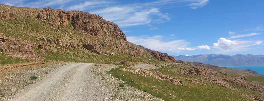
The 82 km sector starting from Sangsangzhen (G219 road) toward the summit of Drong La is a relentless battle against oxygen deprivation. Reaching 5,488m (18,005ft), this is one of the highest motorized points in the world. At this altitude, even heavy-duty 4x4 engines lose nearly 50% of their power, making the unpaved ramps extremely difficult to clear. The surface is often in very bad condition, with deep ruts and loose shale that require a low-range gearbox and constant torque management. Navigating this north-south sector toward Daruoxiang means operating in a "dead zone" where the thin air reduces cooling efficiency, putting your radiator and transmission under extreme thermal stress.
What makes the Zaka La lakeside sector so technical?
Further along the 472 km journey, the road reaches the 77.8 km sector from Wenbuxiang to Nyima, crossing the Zaka La at 4,920m (16,141ft). This part of the track runs along the shores of lake Dangqiong Cuo (Tangshung Tso). The primary hazard here is the road's vulnerability to the rising water levels of the glacial lakes; after a storm, the track can be submerged or severely damaged by localized landslides. The descent from Zaka La toward the shoreline is a high-exposure drive where the soft, eroding shoulders of the dirt path offer no safety margin, and the "washboard" surface makes maintaining steering control a constant struggle.
What are the hazards of the northern Tibet plateau climate?
The weather in the Nagqu prefecture is notoriously unstable, with temperatures dropping from 20°C in the sun to -10°C at night, even in mid-summer. Sudden blizzards and gale-force winds are a constant threat on the open plateau, capable of buffeting high-profile furgonetes dangerously. The isolation is absolute; there is no cell service or civilian infrastructure for hundreds of kilometers along the S205. If you get caught in a storm near the deepest lake in Tibet, Tangra Yumco, the unpaved track can become impassable even for a 4-wheel drive vehicle, leaving you stranded at over 4,200m where altitude sickness is a life-threatening risk.
How to manage the mechanical stress of the 472km Tibet mission?
Reaching the summits of Drong La and Zaka La requires a strictly logistical mindset. You must carry extra fuel, multiple spare tires, and cold-weather survival gear, as a breakdown in this remote sector is a critical emergency. On the steep descents, do not rely on your foot brakes; instead, engage heavy engine braking to control your speed in the thin air. Monitor your vehicle's air filters and battery constantly, as the fine Tibetan dust and extreme temperature swings are primary causes of mechanical failure. In this part of the Transhimalaya, the road is a mission of survival—monitor your gauges, watch the water levels on the lakeshore sectors, and never underestimate the mechanical toll of the high-altitude desert.
Road suggested by: Hugh Wilson
Pic: 陈炜