What are the driving conditions on the Provincial Road 303 (S303) in Tibet?
The Provincial Road 303 (S303) is one of the most technically demanding high-mountain routes in the eastern Tibet Autonomous Region of China. Spanning 709 km (440 miles), this highway connects the G214 Road in Suonacun (Baxoi County, Chamdo) with the China National Highway 317 near Bulong Town. Driving the S303 is a test of mechanical endurance, as the road runs entirely above 4,200 meters, where the lack of oxygen impacts both engine combustion and human physiology.
| Road facts: Provincial Road 303 (S303) | |
|---|---|
| Length | 709 km (440 miles) |
| Max Elevation | 5,086 m (16,686 ft) |
| Average Elevation | Above 4,200 m |
| Vehicle Type | High-clearance 4x4 mandatory |
| Estimated Time | 20+ hours |
What are the main mountain passes along the S303 in Tibet?
Technically, the S303 is a continuous sequence of high-altitude climbs and descents. The road tops out at 5,086m (16,686ft) above sea level at the Zha La pass. This elevation presents a critical challenge for naturally aspirated engines, which can lose up to 40% of their power due to the thin air. The logistical difficulty is amplified by the presence of eight other major passes that define the route:
- Gade La: 5,016m (16,456ft)
- Quzhong La: 4,885m (16,026ft)
- Mob La: 4,802m (15,754ft)
- Red Mud Pass: 4,732m (15,524ft)
- Puti La: 4,483m (14,708ft)
- Tekhar La: 4,476m (14,685ft)
- Ode La: 4,468m (14,658ft)
- Tienpo La: 4,324m (14,186ft)
Each of these summits involves steep gradients and sharp hairpin turns where traction management is essential, especially in the unpaved sectors where the surface is composed of loose gravel and mud.
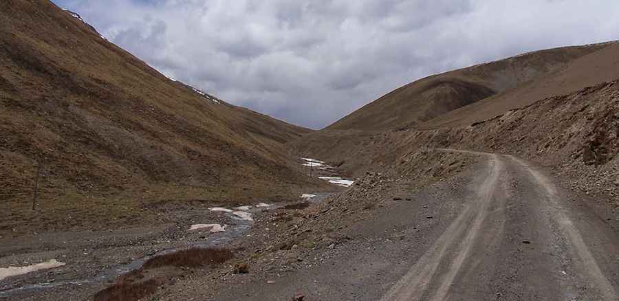
What is the road surface condition of the Provincial Road 303?
The S303 road is a hybrid of paved and degraded sections. While significant portions have been asphalted, the harsh environment causes frequent frost heaving and severe cracks. Technically, the road is in poor condition for much of its 709 km length. Drivers will encounter several unlit tunnels with dripping water and rough, muddy floors. These galleries are often narrow and used by heavy trucks, requiring extreme caution and proper lighting. Due to the deep ruts and the countless hairpins, a 4x4 vehicle with high clearance is the only reliable way to complete the drive safely. Expect a transit time of at least 20 hours under optimal conditions.
How to manage weather and geological hazards on the S303?
The Provincial Road 303 is highly susceptible to the elements. Technically, the road is often underwater or blocked by landslides and debris after heavy rain. Avalanches and heavy snowfalls are a constant threat at these altitudes, and the passes can be closed at any time without notice. Patches of black ice are frequent, particularly on the shaded northern slopes of the passes. Safety protocols mandate that you do not travel this road during severe weather. Landslides can severely damage the asphalt, leaving sections that are only passable with off-road tires. Logistically, the isolation of the S303 means that any mechanical failure at 4,500m could result in a dangerous situation, as support is non-existent for long stretches.
What are the physiological and mechanical demands of the S303?
Driving for 20 hours above 4,200m is an extreme test for the human organism. Most drivers will experience symptoms of altitude sickness (AMS) at levels as low as 2,500–2,800 meters; on the S303, you are operating significantly above that threshold. Mechanically, the vehicle's cooling system must be in perfect condition, as the combination of steep inclines and low air density increases the risk of overheating. The descent from passes like Gade La or Quzhong La requires a consistent engine braking strategy to avoid overheating the brake fluid on the countless hairpins that descend toward the river courses along the route.
Road suggested by: Hugh Wilson
Pic: jlguo