Rong La: The dizzying 22-hairpin ascent in Eastern Tibet
Located in the heart of Dêngqên County, in the eastern reaches of the Tibet Autonomous Region, Rong La is a formidable mountain pass at an elevation of 4,831m (15,849ft) above sea level. This pass is a classic example of high-altitude Himalayan engineering, where the road has to fight for every meter of elevation against a nearly vertical mountainside.
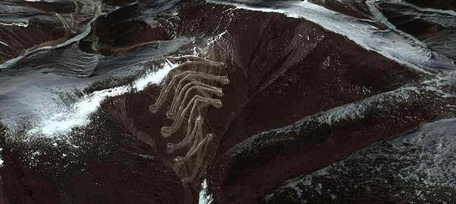
The road to the summit, situated at the coordinates 31.120430, 96.053560, is notorious for its dizzying nature. It is a track that demands a steady hand and a vehicle in perfect mechanical condition. The environment here is characterized by thin air and a fine, pervasive dust that can reduce visibility and clog air filters in seconds. For those prone to vertigo, this route represents a significant psychological and physical challenge.
| Road facts: Rong La (Tibet) | |
|---|---|
| Location | Dêngqên County, Tibet, China |
| Elevation | 4,831 m (15,849 ft) |
| Length (ascent) | 6.41 km (3.98 miles) |
| Hairpin Bends | 22 sharp switchbacks |
| Average Gradient | 6.97% |
How difficult is the climb from Zhuodu to Rong La?
The most technical section of the pass runs north-south, connecting the settlements of Zhuodu and Anlacun. Starting from Zhuodu, the ascent is a concentrated burst of mountain driving: 6.41 km (3.98 miles) long with a relentless elevation gain of 447 meters. While the average gradient is 6.97%, this figure doesn't account for the "staircase" nature of the track. The road climbs through 22 sharp hairpin bends, some so tight that longer 4x4 vehicles may need to perform multi-point turns to clear the corners.
The surface is entirely unpaved, consisting of loose dirt and crushed stone. In dry conditions, the "dizzying and dusty" description is an understatement; trailing vehicles will find themselves in a brown-out zone. 4x4 vehicles with high clearance are essential, not just for the traction but to navigate the deep ruts that form on the inner apex of the switchbacks. As with all high-altitude routes in this region, entering Tibet in your own car requires extensive paperwork and a government-approved guide.
Survival and High-Altitude Maintenance
At nearly 5,000 meters, your engine will be gasping for air. The lack of oxygen reduces power output, meaning you will spend most of the 22 hairpins in first or second gear. It is vital to keep an eye on your engine temperature, as the cooling systems are less efficient in the thin atmosphere. Dust is the other silent killer: ensure your air intake is protected and carry a spare air filter if you are traveling in a convoy.
There are no facilities on Rong La. You are in a remote corner of Dêngqên County where the weather can turn from a dust storm to a blizzard in the blink of an eye. Self-sufficiency is your only safety net. Carry recovery gear, plenty of water, and ensure your braking system is in top shape for the descent, which is just as taxing as the climb. Rong La is an unforgettable drive, but it is one that leaves no room for mechanical or driver error.
Road suggested by: Hugh Wilson