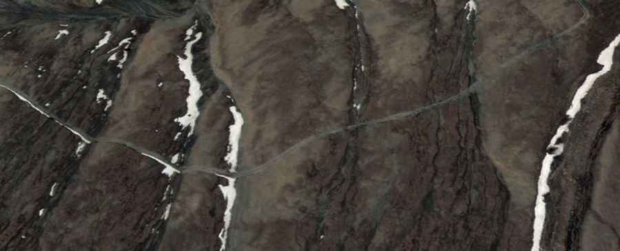
How to drive the military track to Samto La?
The Samto La is an international high mountain pass reaching an elevation of 5,064m (16,614ft) above sea level, situated on the border between China (Tibet) and Nepal (Mustang District). Logistically, this is a dead-end corridor; while the Chinese side is serviced by a military track starting from Qukane, there is no road, trail, or motorable path on the Nepalese side. Driving to the summit requires a high-clearance 4x4 and is strictly restricted to authorized personnel due to its sensitive border location.
| Road facts: Samto La | |
|---|---|
| Location | Saga County (China) - Mustang (Nepal) |
| Elevation | 5,064m (16,614ft) |
| Length | 14.9 km (from Qukane) |
| Average Gradient | 4.15% |
| Status | Military Track (Closed to civilians) |
What is the road condition from Qukane to Samto La?
The 14.9 km ascent from Qukane (Zhongba County) follows a rudimentary dirt track designed for heavy military transport. With an average gradient of 4.15%, the climb is not excessively steep, but the 619-meter elevation gain takes place entirely above 4,400 meters. The surface consists of loose scree and alluvial deposits that can be washed out by seasonal meltwater. Logistically, the track is totally impassable during the winter months when snow drifts and sub-zero temperatures solidify the ground. High-clearance vehicles are a technical requirement to navigate the uneven terrain and potential water crossings that cut through the track during the summer.
Mechanical limits: Engine torque and oxygen at 5,064 meters
Operating a vehicle at Samto La presents extreme mechanical challenges. At 5,064 meters, the atmospheric pressure is roughly 50% of sea-level values. This results in a massive loss of engine torque and power, making low-range gearing essential even on moderate 4% gradients. Cooling systems must be in optimal condition; despite the cold air, the low pressure reduces the boiling point of liquids, increasing the risk of engine overheating under load. For any authorized transit, it is mandatory to use turbocharged diesel engines and high-altitude fuel mixtures to ensure the vehicle does not stall in the thin atmosphere near the border ridge.
What are the border logistics at Samto La?
From a logistical standpoint, Samto La is a high-security zone. The pass links Saga County in Shigatse (Tibet) with the Mustang District in Nepal's Gandaki Province, but there is no cross-border transit for vehicles. The track terminates abruptly at the border line. Navigating this area requires strict adherence to military protocols and established paths; straying from the track is hazardous due to the unpredictable nature of the high-altitude terrain and border restrictions. There is no mechanical support, fuel, or communication infrastructure for at least 100 kilometers, making self-sufficiency and satellite-based communication a technical necessity for any mission in this sector.
Altitude and environmental safety on the Samto La track
The risk of hypoxia and Acute Mountain Sickness (AMS) is a critical safety factor for drivers on Samto La. Physical exertion, such as changing a tire or clearing debris from the track, is significantly more difficult at 16,600 feet. It is a technical protocol to carry portable oxygen and to avoid staying at the summit for extended periods. The environment is extremely arid, and high-velocity winds can create dust storms that reduce visibility to near zero. Before starting the 14.9 km transit, a full check of the vehicle's electrical and heating systems is required, as temperatures at the pass can drop well below freezing even during the mid-summer months.
Road suggested by: Jorge Manuel Gómez Sánchez