Driving the road to Lhari Peak: A 4.861m climb in the disputed Demchok sector
Located in the heart of the disputed Demchok sector between India and China, the track to Lhari Peak is one of the highest and most volatile motorized routes in the Himalayas. Reaching an elevation of 4,861m (15,948ft) above sea level, this unpaved road serves both as a military link for communication facilities and a spiritual path to the Kailash OP Temple (Chota Kailash Shiv Temple). It is a journey defined by extreme altitude, geopolitical tension, and a vertical scale that pushes human and mechanical endurance to the absolute limit.
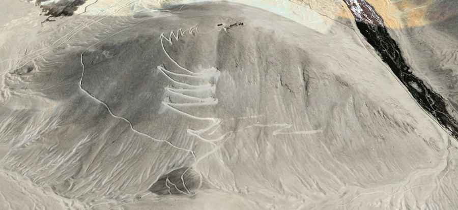
| Road facts: Lhari Peak | |
|---|---|
| Location | Demchok Sector, Ladakh (India/China border) |
| Elevation | 4,861 m (15,948 ft) |
| Length | 7.4 km (from Demchok) |
| Elevation Gain | 602 m |
| Hairpin Turns | 16 |
How challenging is the oxygen-deprived climb to Lhari Peak?
The 7.4 km ascent from Demchok is a brutal logistical challenge. With an average gradient of 8.13% and 16 sharp hairpin turns, the road is a relentless grind on unpaved ground. At nearly 5,000 meters, the notorious absence of oxygen causes a massive drop in engine torque, making it essential to keep your vehicle in low-range gears to maintain momentum. The track is covered in fine glacial dust and loose rocks that can destroy a cooling system if you follow too closely behind another vehicle. Only heavy-duty 4x4s with high clearance can manage the deep ruts and the steep ramps leading toward the "holy mountain."
What are the hazards of the Demchok border military zone?
Operating a vehicle in the Demchok sector means navigating a "dead zone" of extreme weather and military surveillance. The road is completely impassable for most of the year due to heavy snow and ice that block the 16 hairpins. Even in summer, sudden blizzards can reduce visibility to zero, leaving you stranded at an altitude where altitude sickness (AMS) is a real life-threatening risk. The road is shared with heavy military furgonetes and supply trucks, and the proximity to the Line of Actual Control (LAC) means there is zero margin for navigational errors. There is no civilian infrastructure here; if you suffer a mechanical failure, you are entirely dependent on military patrols for rescue.
What is the best mechanical strategy for the Ladakh high-altitude tracks?
Reaching the summit of Lhari Peak requires a vehicle that has been specifically prepared for thin air and sub-zero temperatures. You must ensure your battery and cooling system are in perfect condition, as the combination of steep grades and low atmospheric pressure will find any mechanical weakness. On the descent back toward Demchok, do not ride your brakes; the 602-meter drop over just 7 km will cause rapid brake fade. Use heavy engine braking and pick your line through the loose stones to avoid tire punctures. In this part of the Himalayas, the road is a test of survival—monitor your oxygen levels, watch the horizon for storms, and never underestimate the verticality of the Nyoma tehsil peaks.