Is the old road to Yuximolegai Pass in Xinjiang still drivable?
The journey to Yuximolegai Pass is a trip into the decay of high-altitude engineering. At 3,438m (11,279ft) above sea level, this pass in Nilka County was once a key part of the Duku Highway. However, since the opening of the tunnel that bypasses the summit, the old mountain road has been left to the elements. Without regular maintenance, the path is rapidly returning to a wild state, presenting a significant challenge for any vehicle attempting the climb.
| Road facts: Yuximolegai Pass (Old Duku Highway) | |
|---|---|
| Location | Nilka County, Xinjiang (China) |
| Elevation | 3,438m (11,279ft) |
| Length | 5 km (3.1 miles) from the tunnel entrance |
| Surface | Deteriorating Asphalt / Mud / Loose Scree |
| Status | Bypassed by tunnel / Semi-abandoned |
How is the road surface to Yuximolegai Pass deteriorating?
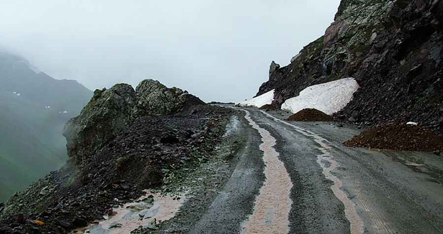
While the old road over the Yuximolegai Daban was originally paved, the current reality is a mess of broken asphalt and mud. As the road is no longer the primary route, frost heave and lack of drainage have destroyed the surface. In many sections, the pavement has been completely covered by rockfalls and mudslides triggered by summer rains. Driving here means dealing with deep ruts and sharp debris that can easily damage the undercarriage of a standard car. High-clearance vehicles are the only safe option to navigate the transition between the remaining asphalt and the raw mountain soil.
What are the main hazards on the old Yuximolegai road?
The most immediate hazard is the high risk of landslides. The steep slopes of the Borohoro Range are unstable, and the abandoned road is often littered with large boulders that force drivers to take dangerous lines near the edge. There are no functioning guardrails, and the steep drops are unprotected. Furthermore, snow patches persist near the 3,438-meter summit well into July, turning the unmaintained road into a slippery trap. If you get stuck here, you are far from the main traffic flow of the new Duku Highway, and recovery will be difficult and expensive.
Why is vehicle size restricted at Yuximolegai Pass?
Authorities officially restrict this section to vehicles with 7 seats or fewer. This is not just a formal rule; the narrowness of the surviving track and the tight, crumbling hairpins make it impossible for larger vans or trucks to turn safely. The shoulder of the road is often soft and prone to collapsing under heavy weight. Even for smaller 4x4s, the drive requires constant attention to the ground ahead to avoid getting bogged down in the slurry of melted snow and fine mountain silt that washes over the pass during the summer months.
When is the best time to attempt the Yuximolegai climb?
The pass is only accessible for about five months a year, usually from June to early October. However, even in mid-summer, the conditions can turn brutal in an hour. Heavy fog often blankets the summit, hiding the ruts and the edge of the cliff. Before leaving the main highway, check for recent mudslide reports in Nilka County. If there has been significant rain, the old road will likely be blocked or too unstable for safe passage. This is a journey through a dying piece of infrastructure where the mountain is reclaiming its territory.
Driving the old Yuximolegai route is a reminder of how quickly a road fails when the maintenance crews stop coming. If you head up there, keep your speed low to protect your tires from the sharp rock shards and stay away from the soft edges of the track. Watch the water runoff across the road, as it often hides deep holes in the old pavement. It’s a raw, high-altitude crawl where you have to read the terrain every meter of the way to avoid a mechanical disaster.
Road suggested by: Jorge Manuel Gómez Sánchez
Pic: Lzy Cn