How to drive the County Road 787 in the Tibetan Plateau?
County Road 787 is a high-altitude unpaved road located in the Ngari Prefecture of the Tibet Autonomous Region. Spanning 139 km (86 miles), this north-south track connects the X711 road with the China National Highway 219. Driving this route involves a sustained elevation of over 5,000 meters, reaching a maximum summit at 5,518 meters (18,103 ft), making it one of the highest roads of China.
| Road facts: County Road 787 | |
|---|---|
| Location | Ngari Prefecture, Tibet, China |
| Length | 139 km (86 miles) |
| Max Elevation | 5,518 m (18,103 ft) |
| Max Gradient | 11% |
| Surface | Unpaved (Dirt and loose gravel) |
What are the driving challenges of the 11% gradient on CR787?
The road features steep ramps where the gradient hits 11%. At 5,518 meters high, the thin air starves the engine of oxygen, cutting vehicle power significantly. Drivers must hold the transmission in low gear to keep the vehicle moving up the steep incline. On the way down, the 11% grade on loose gravel requires continuous engine braking to keep the heavy wheels from locking and sliding on the stones. A high-clearance 4x4 with a low-range transfer case is necessary, especially when summer meltwater turns the dirt base into soft mud.
How to handle the 139 km stretch between X711 and G219?
The 139 km track is completely isolated, with zero fuel stations, villages, or workshops between the X711 junction and the G219 highway. Drivers must carry enough auxiliary fuel for at least 300 km, as low-gear crawling at 5,000 meters doubles normal consumption. Deep snow and frozen permafrost block the route completely throughout the winter months. Due to the extreme altitude, carrying portable medical oxygen is essential to combat mountain sickness during the long drive.
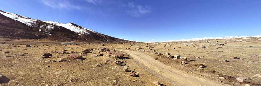
What are the surface conditions near Argog Lake?
The track passes right next to Argog Lake, where the surface consists of hard-packed desert soil and rough gravel. The lane is heavily corrugated with deep washboards that rattle suspensions and can loosen mechanical bolts. Drivers must stay on the main track, as secondary paths lead directly into dead ends or closed military zones. The soil near the lake shore is marshy silt; leaving the established gravel roadbed will immediately bog down a heavy vehicle.
How to prepare a vehicle for the extreme Tibetan altitudes?
Before entering CR787, check that the engine cooling system and hoses are flawless. The cold mountain air puts massive strain on batteries, requiring a strong charging system for morning cold-starts. Lower tire pressure slightly to handle the sharp rocks, but monitor the pressure closely as the altitude changes. Drivers must be fully self-sufficient, carrying a complete mechanical tool kit, two full-sized spare tires, and heavy thermal blankets to survive sub-zero temperatures if forced to stop overnight on the plateau.
Road suggested by: Jorge Manuel Gómez Sánchez
Pic: Grishkoff. PRO