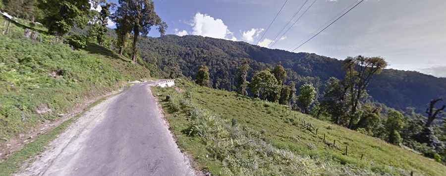
Kori La: Driving the treacherous Bumthang-Ura Highway in Bhutan
Kori La is a high mountain pass at an elevation of 2,406 meters (7,893 ft) above sea level, located in the Mongar District of eastern Bhutan. Situated within the steep ridges of the Himalayan foothills, the route through the pass is a section of the Primary National Highway 1 (PNH1). Although officially a paved road, the route consists of heavily deteriorated asphalt, deep potholes, and raw gravel patches with zero side protections.
| Road facts: Kori La | |
|---|---|
| Location | Mongar District, Eastern Bhutan |
| Elevation | 2,406 m (7,893 ft) |
| Route Official Name | Primary National Highway 1 (PNH1) |
| Length | 256 km (159 miles) between Chamkhar and Trashigang |
| Surface | Broken asphalt and loose gravel sections |
How rough is the PNH1 road over Kori La?
The 256-kilometer mountain highway crosses the central-eastern interior of Bhutan, linking Chamkhar with Trashigang. The original asphalt from the 1990s is completely rotted out, leaving the driving line full of tire-slashing potholes and long unpaved sections where the pavement has vanished into bare stone beds. The route climbs through a non-stop sequence of single-lane hairpin turns carved straight into the steep mountainsides. These bends are extremely tight, forcing larger transport trucks to perform multi-point turns right on the edge of sheer drop-offs that completely lack steel guardrails or concrete barriers.
Why does heavy mist turn Kori La into a blind drive?
The geographic position of Kori La causes thick mountain mist and low cloud layers to roll over the summit constantly. This heavy white-out regularly drops visibility down to less than five meters in a matter of seconds, turning the narrow curves into blind traps. The high moisture from the fog settles directly onto the broken tarmac and stone beds, making the steep ramps and sharp hairpins slick, particularly in the dense forest sections where the road remains permanently wet and shaded from sunlight.
What damage can winter and spring thaws cause on the Kori La pass?
At an altitude of 2,406 meters, winter blizzards dump heavy snow across the pass, packing the narrow lanes with deep drifts that force local authorities to shut down the highway gates for 24 to 48 hours until plows clear the route. During the spring thaw between April and May, the melting ice and seasonal rainstorms loosen the upper earth banks. This triggers sudden mudslides and rockfalls that drop large boulders onto the narrow asphalt lanes, cutting the road width down and forcing high-clearance vehicles to pick lines around fresh debris next to vertical canyon drops.