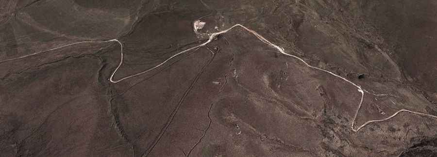
Driving the Tsar-Verin Shorjha pass: A high-altitude 4x4 track on the Armenian border
Reaching an elevation of 2,748m (9,015ft) above sea level in the Vardenis Mountains, the Tsar-Verin Shorjha pass is one of the most isolated and geopolitically sensitive tracks in the Caucasus. Connecting the Gegharkunik Province in Armenia with the Kalbajar District in Azerbaijan, this 17.6 km (10.9 miles) dirt road is a relic of Soviet-era connectivity that has been reclaimed by the elements and military patrols. It is a route where the "road" is often just a set of deep ruts cut into the high-altitude plateau.
| Road facts: Tsar-Verin Shorjha | |
|---|---|
| Location | Armenia - Azerbaijan border (Vardenis Range) |
| Elevation | 2,748 m (9,015 ft) |
| Length | 17.6 km (10.9 miles) |
| Surface | Unpaved (Dirt, Deep Ruts and Loose Stone) |
| Hazard Level | Extreme Isolation & Military Zone |
How challenging is the road from Verin Shorzha to Tsar?
The 17.6 km transit between Verin Shorzha and the village of Zar (Tsar) is a relentless 4x4 test. The surface is an infamous dirt track characterized by deep ruts and high-center bumps that will punish any vehicle without significant ground clearance. As you can see on the ground, the path follows the natural contours of the treeless high plateau, where the "track" is constantly shifting due to erosion and heavy military vehicle transit. Expect slow progress; the "bumped" nature of the terrain usually restricts speeds to below 20 km/h to avoid snapping a suspension link or damaging the oil pan.
What are the hazards of the Vardenis mountain pass?
The real danger here is the total absence of a safety net. At 2,748 meters, the weather can flip in minutes. A summer thunderstorm transforms the dry, dusty soil into a slippery clay-like trap that can leave even the best 4x4 spinning its wheels on the steep ramps. Due to the proximity to international military lines (coordinates 40.06583, 45.90392), staying strictly on the established track is not just a suggestion—it’s a survival requirement. There is no cell service, no electricity, and the only other humans you’ll encounter are seasonal shepherds or soldiers. If you have a mechanical failure here, you are facing a long, cold walk into a high-consequence border zone.
Winter closures and mechanical self-sufficiency
Because there is zero snow clearance on this remote ridge, the Tsar-Verin Shorjha pass is impassable for at least six months of the year, typically from late October until early June. Even in mid-summer, patches of snow can block the higher gullies. Before attempting this route, your vehicle must be "hardened" for the high-altitude wilderness: carry a full-sized spare, heavy-duty recovery boards, and enough fuel to account for low-gear crawling. In this part of the Caucasus, your mechanical preparation is the only thing standing between an expedition and a disaster.