How to drive the 10% average gradient of K’ashat’agh?
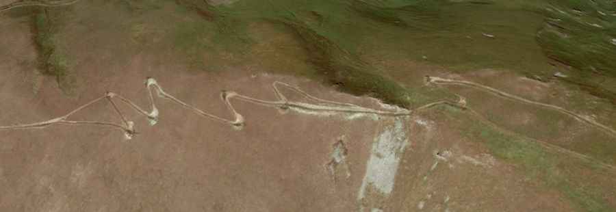
K’ashat’agh is an international mountain pass at an elevation of 2,874 meters (9,429 ft) above sea level, located on the border between the Gegharkunik Province of Armenia and the Gadabay District of Azerbaijan. The unpaved mountain track links the village of Artanish with the rugged border crest, climbing directly through the steep slopes of the Lesser Caucasus range.
| Road facts: K’ashat’agh | |
|---|---|
| Location | Armenia (Gegharkunik) - Azerbaijan Border |
| Elevation | 2,874 m (9,429 ft) |
| Length | 8.7 km (5.4 miles) from Artanish |
| Elevation Gain | 875 meters (2,870 ft) |
| Average Gradient | 10.05% |
| Surface | Unpaved (Raw soil and loose mountain scree) |
What are the driving challenges of the K’ashat’agh climb?
The 8.7 km ascent from Artanish to the summit crest climbs a vertical 875 meters with a sustained average gradient of 10.05%. The unpaved track features sharp, unbanked switchbacks where the incline spikes past the average mark. A proper 4x4 vehicle with a low-range gearbox is necessary to crawl up the loose dirt without stalling. If you lose momentum or select the wrong gear, restarting the vehicle on these steep, uncompacted dirt ramps is extremely difficult as the tires will simply dig into the soft ground.
How to manage traction and tires on the K’ashat’agh road?
The track surface consists of raw mountain soil and loose stone debris. The steep 10% incline shifts the vehicle weight heavily to the rear axle, causing the front wheels to slip on the loose stones. Aggressive all-terrain or mud-terrain tires are needed to bite into the dirt switchbacks. Sharp, jagged rocks stick out of the track bed, presenting a constant risk of slicing open tire sidewalls under the heavy acceleration required to complete the 875-meter climb.
What are the seasonal hazards and winter closures of K’ashat’agh?
At 2,874 meters high, the pass is blocked by heavy winter snow and deep mud from October until late June. The remote border track receives zero snowplow or maintenance work. During the summer months, sudden mountain downpours wash away the dirt surface, cutting deep ruts and washouts directly across the climbing lanes. There are no shelters, fuel stations, or emergency service crews anywhere along the 8.7 km track.
What is the current status of the Armenia-Azerbaijan border at K’ashat’agh?
The pass cuts through a volatile border zone regulated by military checkpoints. Because of the ongoing regional conflict, the track functions as a dead end rather than a through-route, and armed outposts block access near the crest. The entire 8.7 km climb lacks any civilian infrastructure. Drivers must carry extra fuel and full recovery gear, as crawling up a 10% dirt gradient in low gear doubles standard fuel consumption rates.