What are the most spectacular roads in Azerbaijan?
Azerbaijan is a country located in the Caucasus region, at the junction of Eastern Europe and West Asia. Covering an area of 86,600 km², it’s about the size of Portugal.
The country is dominated by the Caspian Sea, the Greater Caucasus, and extensive flatlands, so when you plan a road trip in Azerbaijan, you’ll face a lot of challenges while discovering tales of ancient caravan routes and modern marvels. The country's landscape is also characterized by numerous rivers and lakes, so your trip across the country will make you feel like a pro driver.
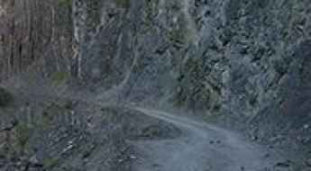
As a part of the former Soviet Union, don’t skip driving the treacherous road to Lahıc with huge cliffs and 300m drops, or the road to Khinalug, one of the highest towns in the Caucasus, at 2,350m (7,710ft) above sea level. It’s said to be the most remote and isolated village in Northeastern Azerbaijan and among the highest in the Caucasus. The defiant unpaved road to David Gareja Monastery is worth a drive, leading to a rock-hewn Georgian Orthodox monastery complex. It’s perhaps the most remarkable of all Georgia's ancient sites. In Azerbaijan, every road is an adventure and every turn a story.
The Road to Lahıc: A Treacherous Route with Huge Cliffs and 300m Drops
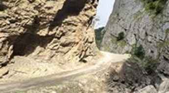
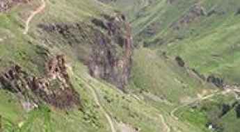
Lahıc is a small town located in the Ismailli Rayon of Azerbaijan. The road to the village is one of the most dangerous drives in the world. It follows a river with huge cliffs and 300m drops.
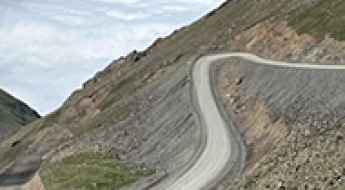
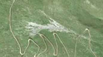
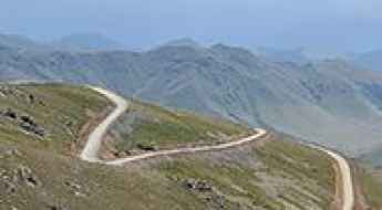
The road to Omar Pass in Azerbaijan's Lesser Caucasus is only for experienced drivers
Ömər Aşırımı is a high mountain pass at an elevation of 3,252 m (10,669 ft) above sea level, located in the region of Ganja-Gazakh, in Azerbaijan.
The wild unpaved road to Lake Maralgol in Azerbaijan
Lake Maralgöl is a high mountain lake at an elevation of 1,910m (6,266ft) above sea level located in the region of Ganja-Gazakh, in Azerbaijan. It’s one of the most beautiful and picturesque places in the country.
How to get by car to Lake Goygol in Azerbaijan?
Lake Göygöl is a high mountain lake at an elevation of 1.556m (5,104ft) above sea level, located in the region of Ganja-Gazakh, in Azerbaijan
The Road to Khinalug, One of the Highest Towns in the Caucasus
Khinalug is a high mountain town at an elevation of 2,350m (7,710ft) above sea level, located in Azerbaijan. It’s said to be the most remote and isolated village in the northeastern part of the country, and among the highest in the Caucasus.
Driving the Wild Road to Mount Kapaz
Mount Kapaz is a high mountain peak located in the Goygol region of Azerbaijan. A narrow and curvy unpaved road, north of the summit, climbs up to an elevation of 2,893m (9,491ft) above sea level.
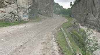
Travelling the Cliff Road Through the Tengealti Canyon
Tengealti Canyon is a very scenic canyon located in the Guba-Khachmaz region of Azerbaijan. A dangerous cliff road runs along it.
How to Get by Car to David Gareja Monastery in Kakheti?
Located in the Kakheti region of Georgia, David Gareja Monastery is a rock-hewn Georgian Orthodox monastery complex. It’s perhaps the most remarkable of all Georgia's ancient sites.
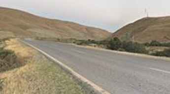
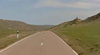
How to drive the scenic road from Gilazi to Altiaghach?
Located in the Khizi Rayon of Azerbaijan, the road from Gilazi to Altiaghach is a very scenic drive, with stunning views.

A slippery street with black ice in Baku
On January 26, 2016, a severe cold snap in Baku, the capital of Azerbaijan, resulted in a rare and technical road hazard known as black ice. A specific junction in the city became the site of multiple uncontrolled slides involving buses, trucks, and passenger cars, highlighting the risks of driving in regions where infrastructure is not winter-ready.
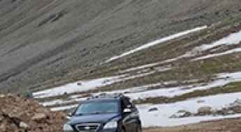
The road to Laza is recommended for drivers with strong nerves
Laza is a high mountain village at an elevation of 1.670m (5,479ft) above the sea level well known with its numerous waterfalls, located in the Qusar Rayon of Azerbaijan. Drive with care as this is a mountain road with hairpin curves and dangerous drop offs.
The Ultimate Road Trip Guide to Mount Kaputjug
Mount Kaputjugh is a high mountain peak located on the border of Armenia and Azerbaijan.
How to get by car to Sev Lake on the border of Azerbaijan and Armenia
Sev Lake is a glacial lake at an elevation of 2.678m (8,786ft) above sea level, located on the border of Azerbaijan and Armenia.
East Sevan Ridge
East Sevan is a ridge at an elevation of 3.376m (11,076ft) above the sea level, located on the border of Armenia and Azerbaijan.
Driving the Tsar-Verin Shorjha pass: A high-altitude 4x4 track on the Armenian border
Reaching an elevation of 2,748m (9,015ft) above sea level in the Vardenis Mountains, the Tsar-Verin Shorjha pass is one of the most isolated and geopolitically sensitive tracks in the Caucasus. Connecting the Gegharkunik Province in Armenia with the Kalbajar District in Azerbaijan, this 17.6 km (10.9 miles) dirt road is a relic of Soviet-era connectivity that has been reclaimed by the elements and military patrols. It is a route where the "road" is often just a set of deep ruts cut into the high-altitude plateau.
Hongur Lerr
Hongur Lerr is a high mountain peak at an elevation of 3.052m (10,013ft) above the sea level, located in the Kalbajar Rayon of Azerbaijan.
Road trip guide: Conquering Mount Gomshasar
Mount Gomshasar is a high mountain peak at an elevation of 3.542m (11,620ft) above the sea level, located in the region of Ganja-Gazakh, in Azerbaijan.