Pavarotlar: Driving the brutal Soyuq Yolu in the Zengezur Mountains
Pavarotlar is one of the most extreme high-altitude points in the Nakhchivan enclave of Azerbaijan. Reaching an elevation of 3,132m (10,275ft) above sea level, this mountain peak sits directly on the border with Armenia within the rugged Zengezur mountain range. The road to the summit, known locally as Soyuq Yolu, is a formidable mountain track that ranks among the highest mountain roads of Armenia and Azerbaijan, offering a vertical challenge that few vehicles can sustain.
| Road facts: Pavarotlar | |
|---|---|
| Location | Ordubad Rayon, Nakhchivan (Azerbaijan-Armenia border) |
| Max Elevation | 3,132m (10,275ft) |
| Length | 15 km (9.3 miles) |
| Average Gradient | 12.55% |
How challenging is the climb from Gənzə to Pavarotlar?
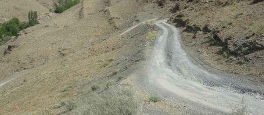
The ascent to Pavarotlar begins in the village of Gənzə, situated at 1,249 meters. From this point, the Soyuq Yolu covers a 15-kilometer stretch that gains a staggering 1,883 meters in elevation. The challenge of this route is the unrelenting gradient, which averages 12.55% and features several ramps hitting 16%. This is a sustained vertical push on a surface that is a mix of loose gravel, jagged rocks, and deep ruts. Driving these steep sections requires a 4x4 vehicle with a low-range gearbox and excellent cooling capacity, as the engine will be working at high revs for the entire duration of the climb in a low-oxygen environment.
Why is the Soyuq Yolu track so technical for 4x4 vehicles?
The road through the Zengezur range is notoriously tippy and bumpy. The technical difficulty lies in the combination of extreme steepness and the unpredictable nature of the mountain soil. During wet conditions, the Soyuq Yolu turns into a muddy trap where traction is almost non-existent. The track is narrow, with significant vertical exposure and no safety barriers, meaning any error in steering or throttle control on the 16% ramps can have immediate consequences. This is a road for experienced drivers who understand how to manage weight distribution on uneven, rocky surfaces where the vehicle is constantly pitching and rolling.
Is the road to Pavarotlar passable during the winter?
At an elevation of over 3,100 meters, the Pavarotlar peak is buried under heavy snow for most of the year. The pass is completely impassable during the winter months and often remains blocked well into late spring. The extreme weather of the border region means that sudden storms can strike even in summer, turning a dry, rocky trail into a dangerous washout in minutes. Because of its strategic border location, the road is primarily used for military or seasonal purposes, and maintenance is minimal. Before attempting the drive, you must be fully self-sufficient with recovery gear, spare tires, and extra fuel, as help is non-existent in this remote sector of the Zengezur mountains.
What are the hazards of the Azerbaijan-Armenia border road?
Navigating the Pavarotlar summit involves more than just mechanical challenges; it is a high-consequence drive due to the lack of infrastructure and the steepness of the terrain. The descent is as taxing as the climb, putting immense thermal stress on the brakes. Relying on engine braking is the only way to safely manage the 12.55% average descent back to Gənzə. The road is a dead-end on the Azerbaijani side, and given the sensitivity of the border area, drivers should remain on the main track. It is a raw, high-altitude transit where the mechanical integrity of your 4x4 and your ability to read the crumbling mountain edges are the only guarantees of a safe return.
Pic: http://ordubad.ucoz.com/photo/ordubad/2-0-20