Mohammediyah Mountain Road: The steep alternative to Al-Hada in Saudi Arabia
Located in the Makkah Province of western Saudi Arabia, the Mohammediyah Mountain Road is a breathtaking and demanding drive through the Sarawat Mountains. Reaching an elevation of 2,250m (7,381ft) above sea level, this route is famous for its stunning views of the Red Sea coast and its role as a vital, yet lonely, alternative to the often-congested Al-Hada highway.
| Road facts: Mohammediyah Mountain Road | |
|---|---|
| Location | Makkah Province, Saudi Arabia |
| Max Elevation | 2,250 m (7,381 ft) |
| Pass Name | Aqabat Al Shafa |
| Length | 20 km (mountain stretch) |
| Surface | Fully paved (Single lane) |
Where is the Mohammediyah Mountain Road?
The road connects the coastal settlement of Umm az Zillah with the mountain city of Ash Shafa, on the outskirts of Taif. This pass, known as Aqabat Al Shafa, carves through the rugged Sarawat range, offering a direct link between the Red Sea coast and the high plateaus. Completed around 2010, it is a relatively new addition to the region's infrastructure, designed to provide a scenic and strategic bypass for those heading to the mountains.
Is the Mohammediyah Mountain Road a motorway?
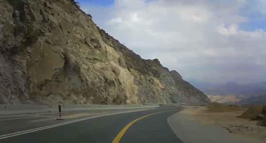
No, this is a single-lane road per direction, not a high-speed motorway. While the entire route is fully paved, the driving conditions are far from standard. The road is carved directly into cliffs, with rocks everywhere and a notorious lack of shoulder room. Over a stretch of 20 kilometers, you will encounter hundreds of turns, many of them extremely sharp. The climb is constant, rising from the valley floor to over 2,250 meters, requiring steady focus and constant gear changes to manage the incline.
Is it safe to drive the Mohammediyah Road at night?
Driving this road at night is strongly discouraged. There is no lighting along the mountain pass, and the sheer number of sharp curves makes it extremely hazardous in the dark. In several sections, the road lacks guardrails, leaving no margin for error if you misjudge a turn. Visibility is your best ally on this route, as the geography is unforgiving. Daytime driving is much safer, allowing you to anticipate oncoming traffic and navigate the "cliff-hanging" sections with more confidence.
What are the hazards when it rains on Aqabat Al Shafa?
Rain is a major risk factor for the Mohammediyah Road. The steep, rocky walls are prone to erosion, and landslides or falling rocks can block the path during a storm. Because of this, the authorities usually close the road during rainy weather. Additionally, the road is a "lonely" one; for about 1 hour and 30 minutes, you will find no services, no mobile phone coverage, and no internet. If you run into mechanical trouble or get caught in a storm, help will not be easy to find. Proper vehicle preparation and a full tank of fuel are mandatory before starting the ascent.
Why use the Mohammediyah Road instead of Al-Hada?
Despite its dangers, this road is an excellent alternative to the Al-Hada road. Al-Hada is often crowded, especially during holidays, peak hours, or when it is closed for maintenance. The Mohammediyah route also helps drivers avoid the heavy truck traffic typical of the Al-Sail road. Furthermore, during the Hajj season, it serves as a great way to bypass the numerous checkpoints found on the main highways. If you have the skill to handle a technical mountain drive and want to see the "awesome" rocky landscapes of the Shafa region, this is the route to take.
Road suggested by: jorge manuel gómez sánchez
Pic&video: MyTravelVeedes