How to drive the dangerous Lapis Route through Sabzak Pass?
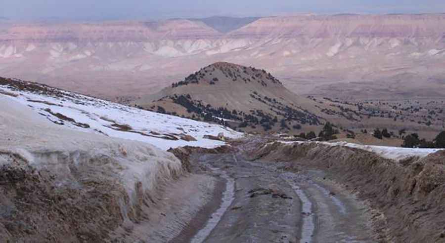
Sabzak Pass (Kōtal-e Sabzak) is a high mountain pass at an elevation of 2,552 meters (8,372 ft) above sea level, located on the boundary between Herat and Badghis provinces in northwestern Afghanistan. Part of the historical Lapis Route, this 32.9 km unpaved sector connects Masjed-e Chubi with Musami through a severely degraded dirt ledge that combines extreme terrain decay with heavy security risks.
| Road facts: Sabzak Pass | |
|---|---|
| Location | Herat / Badghis Border, Afghanistan |
| Elevation | 2,552 m (8,372 ft) |
| Length | 32.9 km (20.4 miles) |
| Surface | Unpaved (Severely broken dirt and loose stones) |
| Main Hazard | Deep frost ruts, mud traps, and ambushes |
What are the road conditions of the Sabzak Pass?
The 32.9 km track is in dreadful condition due to zero maintenance and harsh mountain weather. The winter freeze-thaw cycles destroy the soil structure, causing the dirt surface to split, buckle, and form deep horizontal rases and ridges. These hard, frozen ripples make it impossible to hold a steady speed and can easily snap axles or blow out suspension struts. The path is covered in deep ruts and sharp loose scree, requiring a high-clearance 4x4 with reinforced tires to avoid a mechanical breakdown in the middle of nowhere.
Why is the Sabzak Pass track a bottleneck for drivers?
The mountain crossing between Masjed-e Chubi and Musami is highly unpredictable. High-velocity winds hit the bare mountain face, triggering sudden dust storms in summer and thick snowdrifts in winter that drop driving visibility to zero. The track becomes completely blocked by heavy snow from December to March. During the spring thaw, the melting water mixes with the loose topsoil, turning the entire 32.9 km route into a deep mud trap. Drivers must carry heavy tow straps, winches, and sand ladders, as no recovery trucks or roadside assistance exist in the province.
What are the security dangers on the Kōtal-e Sabzak?
Beyond the broken ground, the pass runs through an active conflict area with a high risk of armed ambushes, illegal checkpoints, and attacks. The narrow, unbanked hairpins force vehicles to drop down to walking speeds, making them easy targets. Drivers must complete the crossing during broad daylight and travel in groups of multiple vehicles. A mechanical failure or a flat tire on these isolated slopes leaves you completely vulnerable, making a thorough vehicle check before climbing mandatory. Cell phone towers are absent across the entire 2,552-meter ascent, requiring satellite radios for any emergency call.
Road suggested by: Hugh Wilson
Pic: http://sharingmeanscaring.blogspot.com/2007/02/sabzak-pass_02.html