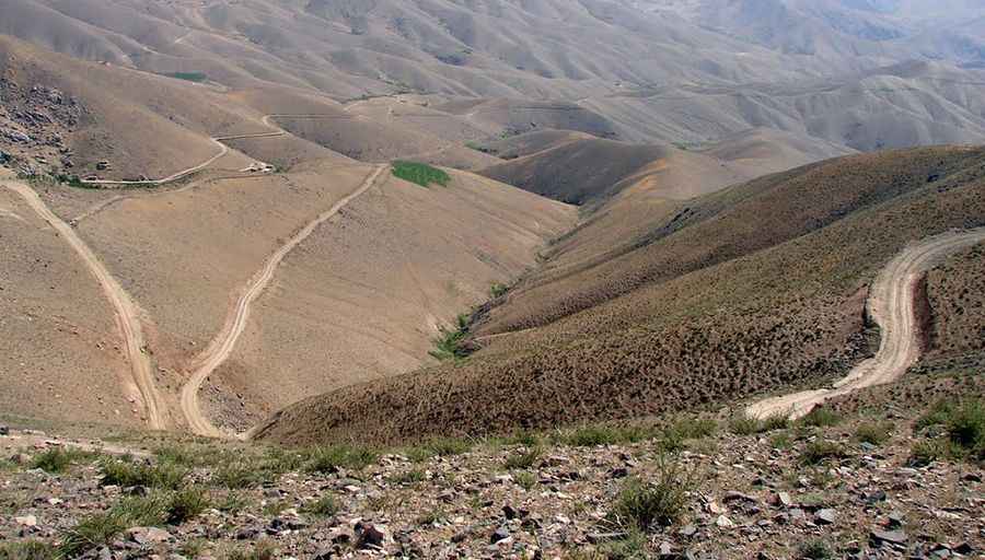
Driving the unpaved National Highway 39 to Kotal-e Tamazan
Kotal-e Tamazan is a high mountain pass at an elevation of 2,413m (7,916ft) above sea level on the border between Urozgan and Daykundi provinces in central Afghanistan. The pass is part of the National Highway 39 (NH39), a 56 km dirt track that connects Gizab and Nili.
| Road facts: Kotal-e Tamazan (NH39) | |
|---|---|
| Location | Urozgan / Daykundi, Afghanistan |
| Elevation | 2,413 m (7,916 ft) |
| Length | 56 km (34.8 miles) |
| Surface | Unpaved / Dirt and Rock |
How is the road NH39 to Kotal-e Tamazan?
The 56 km drive is a primitive dirt track that is barely wide enough for one truck in many sections. The surface is a mix of fine dust and loose stones that offer very little grip. There are no drains or walls, so the road is constantly washed out by water, leaving deep ruts that can catch the belly of the car. You need a high-clearance 4x4 to overcome the steep ramps and the rocky debris that litters the climb between Gizab and Nili. There is zero room for steering errors on the cliff edges.
What are the driving conditions between Gizab and Nili?
The NH39 changes completely with the weather. A bit of rain turns the dirt into a thick mud that makes the steep descents from 2,413 meters a nightmare for the brakes. Rockfalls are a constant threat, and you might find the path blocked by boulders at any turn. There are no gas stations, no workshops, and no help for the entire 56 km stretch. You must carry everything: extra fuel, water, and tools to dig yourself out, as you are completely on your own in this mountain corridor.
Is the road to Kotal-e Tamazan open in winter?
Snow and ice usually shut the pass down for weeks during the winter. There are no snowplows in this part of Afghanistan, so once the snow falls, the road is blocked until it melts. Even in the spring, the thaw makes the ground unstable and can cause the edges of the track to collapse under the weight of a vehicle. Beyond the mud and rocks, the area is isolated and unstable; you need to be sure your car is in perfect mechanical shape because a breakdown here means being stranded in one of the most remote places in the central highlands.
Road suggested by: Hugh Wilson
Pic: R-C