What are the most spectacular roads in Afghanistan?
Afghanistan is a landlocked country, located on the Iranian Plateau, at the crossroads of Central Asia and South Asia. Despite its natural wonders, right now is better to avoid all travel to Afghanistan, due to terrorism, risk of wrongful detention, kidnapping and crime.
The country is 652,864 km2 (252,072 sq mi), and bordered by 6 countries: Pakistan, Iran, Turkmenistan, Uzbekistan, Tajikistan and China. We advise against all travel to and within Afghanistan. Border crossing points may be closed without notice, especially during increased border tensions or concerns about increased risk of a terrorist attack. There are Taliban checkpoints on roads throughout the country and in Kabul.
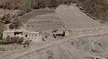
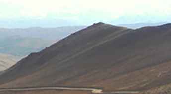
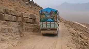
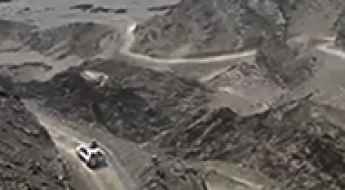
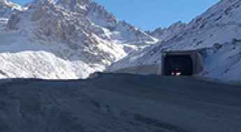
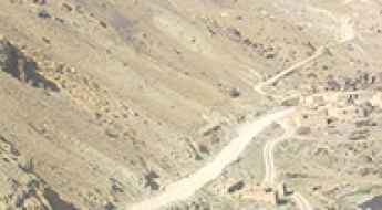
Despite the risks, the country features many spectacular roads, some of them among the most challenging in the world, on a landscape characterized by rugged mountains, vast deserts, and fertile valleys. Navigating the Kabul-Jalalabad Highway is a difficult drive in Taliban territory following the Kabul River Gorge for 64 kilometers (40 mi). This two-lane highway runs through 600-meter-high cliffs. Salang Pass is a mountain pass at 3,878m (12,723ft) on the boundary between Parwan and Baghlan provinces. Back to war times, Highway 1 is the Afghan Highway to Hell. And the hostile and toxic Salang Tunnel sits at 3,400m (11,154ft) above sea level, with limited lighting, inadequate ventilation, and marred by potholes.
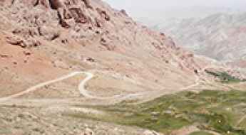
The road to Kotal-e Unak is not for the faint of heart
Kotal-e Unak is a high mountain pass at an elevation of 3.056m (10,026ft) above the sea level, located in Daykundi Province, in the central part of Afghanistan.
Sangarkish Pass: Driving the V 220902 Road in Daykondi
At an elevation of 3,202m (10,505ft) above sea level, Kotal-e Darwazah (also known as Sangarkish Pass) is a high mountain crossing in the Daykondi Province of central Afghanistan. The route is part of the V 220902 road, a critical but primitive link through the rugged mountainous terrain of the region.
Isparman Pass: The Afghan Route of Three Passes (Max. 2,716m)
The Kotal-e Isparman (Isparman Pass) is the heart of an extremely challenging high mountain route that includes three closely situated passes in the Farah province of Afghanistan. Although Isparman Pass itself reaches 2,706 meters (8,877 ft), the road’s highest point is nearby at Darah-ye Chashmah-ye Malaki (2,716m). This unpaved road demands maximum driver preparation due to its extreme remoteness and degraded infrastructure.
Driving the heights of Sabz Chob Pass in Afghanistan's Ghazni Province
Sabz Chob is a high mountain pass at an elevation of 2.917m (9,570ft) above the sea level, located in Jaghori District in Ghazni Province of Afghanistan.
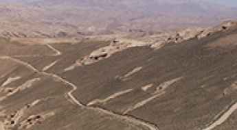
Kotal-e Aq Rabat: Driving the 43km unpaved track in Bamyan
Kotal-e Aq Rabat is a high mountain pass at an elevation of 3,362 meters (11,030 ft) above sea level, located in the Sayghan District of the Bamyan Province, Afghanistan. The road through the pass is a 43.3-kilometer unpaved track that crosses the arid highlands of the Hindu Kush foothills. The physical reality of driving this route involves managing a surface of compacted dirt and deep sand where the extreme dust and sustained steep grades test the vehicle's filtration system and low-end torque to their absolute limits.
A gravel road to the summit of Kotal-e Yamahgak
Pereval Yamagak is a high mountain pass at an elevation of 2.481m (8,139ft) above the sea level, located in central Afghanistan.
Navigating the hazardous road to Kotal-e Gardish Pass
Kotal-e Gardish is a high mountain pass at an elevation of 3.058m (10,032ft) above the sea level, located in Ashtarlay District of Daykundi Province in Afghanistan.
How difficult is the unpaved road to Nowjok Pass in Daykundi?
Kotal-e Nowjok is a high mountain pass at an elevation of 2,722m (8,930ft) above sea level, located in the Daykundi Province of central Afghanistan. Situated in one of the most isolated regions of the country, the pass is a critical but treacherous link in the Hindu Kush foothills. The road is a raw, unpaved track where the lack of infrastructure and the extreme terrain create a driving environment that is as mechanically demanding as it is psychologically taxing.
Driving the wild and unpaved road to Bagak Pass
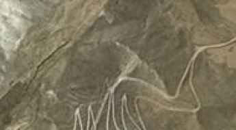
Kotal-e Bagak, popularly known as Bagak Pass, is a high-altitude mountain crossing reaching 3,516 meters in the Bamyan Province of central Afghanistan. This is a raw, high-desert track that cuts through the heart of the Bande Pitaw region, offering a drive that is as spectacular as it is brutal. It is a world of crumbling rock and vertical drop-offs where the road is barely a scratch on the side of the mountains. Driving here requires more than just a 4x4; it requires a vehicle in perfect mechanical condition and a driver who can handle hundreds of hairpins in one of the most remote and isolated areas of the Hindu Kush.
Kotal-e Mianah: Driving the remote 121km pass in Central Afghanistan
Reaching an elevation of 3,544m (11,627ft) above sea level, Kotal-e Mianah (also known as Mianah Pass) is a high mountain crossing located in the Bamyan Province of central Afghanistan. This long-distance mountain track is one of the most isolated and demanding drives in the region, crossing the rugged heart of the Hindu Kush mountains.
How to drive the unpaved road to Nargis Pass in Central Afghanistan?
Kotal-e Nargis is a high mountain pass at an elevation of 3,134m (10,282ft) above sea level, located in the province of Wilāyat-e Bāmyān, Afghanistan.

How to drive the unpaved road to Zardalu Pass in Ghazni province?
Kōtal-e Zardālū is a high mountain pass at an elevation of 2.669m (8,756ft) above sea level, straddling Jaghori and Qarabagh districts of Afghanistan.
Driving the wild road to the top of Surkh Pass
Kotal-e Surkh is a high mountain pass at an elevation of 1.980m (6,496ft) above sea level, located in the Farah province of Afghanistan.
How dangerous is the unpaved road to Kotal-e Khuni in Afghanistan?
Kotal-e Khuni, often referred to as the "Pass of Blood," is a high mountain crossing reaching an elevation of 1,891m (6,204ft) above sea level in southern Afghanistan. Straddling the border between Helmand and Uruzgan provinces, the pass is a brutal example of Afghan mountain travel. It is a raw, unpaved track where the combination of extreme isolation, shifting sandy sections, and the constant flow of heavy commercial traffic turns every kilometer into a high-stakes test of nerves and mechanical endurance.
Road trip guide: Conquering the Challenging Kajak Pass
Kotal-e Kajak is a high mountain pass at an elevation of 2.830m (9,284ft) above sea level, located in the Daykundi Province of Afghanistan.
The unpaved road with hundreds of turns to Narai Kandao
Narai Kandao is a mountain pass at an elevation of 645m (2,116ft) above sea level, located in eastern Nangarhar Province, Afghanistan.
What are the highest roads in Afghanistan?
Afghanistan is a landlocked country located at the intersection of Central and South Asia, historically crucial as a major connection point along the Silk Road. It is bordered by Iran (west), Pakistan (south and east), Turkmenistan, Uzbekistan, and Tajikistan (north), and China (northeast).
Driving the wild unpaved road to Shewa Pass
Kotal-e Shewa is a high mountain pass at an elevation of 2.705m (8,874ft) above sea level, located in Badakhshan Province in Afghanistan.
Driving the A77: The rugged mountain road through Kōtal-e Nāwêr and Mullā Ya‘qūb
The A77 is a daunting high-mountain road located in central Afghanistan, crossing through the Maidan Wardak and Bamiyan provinces. Spanning 135 km (84 miles) of unpaved terrain, this remote track summits two major mountain passes—Kōtal-e Nāwêr and Kōtal-e Mullā Ya‘qūb—offering a true backcountry driving experience along the river valleys of the Hindu Kush.
How to drive the unpaved road to Qarah Kotal in Samangan
Qarah Kōtal is a high mountain pass at an elevation of 3.063m (10,049ft) above sea level, located in Samangan Province in Afghanistan. The decision to travel is the sole responsibility of the traveller. The traveller is also responsible for his or her own personal safety.
How to drive the 25-hairpin turns to Koh-e Nihalah in Samangan?
Koh-e Nihalah is a high mountain peak at 2,980 meters (9,776 ft) above sea level, located in the Samangan Province of Afghanistan.
How to drive the riverbed track to Kotal-e Kurang in Badakhshan
Kotal-e Kurang is a high mountain pass at an elevation of 3,363 meters (11,033 ft) above sea level, located in the Badakhshan Province of Afghanistan. The track to the pass often disappears into riverbeds and deep mud, following the natural flow of snowmelt through the Hindu Kush mountains.
How to drive the unpaved road to Kōtal-e Darah-ye Rāst in Afghanistan?
Kōtal-e Darah-ye Rāst is a high mountain pass at an elevation of 4,188m (13,740ft) above sea level located in Afghanistan. It is one of the highest roads in the country.