Before the Road Disappears: A Practical Navigation Plan for Remote Drives
Remote roads reward preparation. A beautiful pass can have long stretches without mobile coverage, fuel, lighting, or a safe place to turn around. Even a familiar car becomes less reassuring when its route display cannot show the next junction.
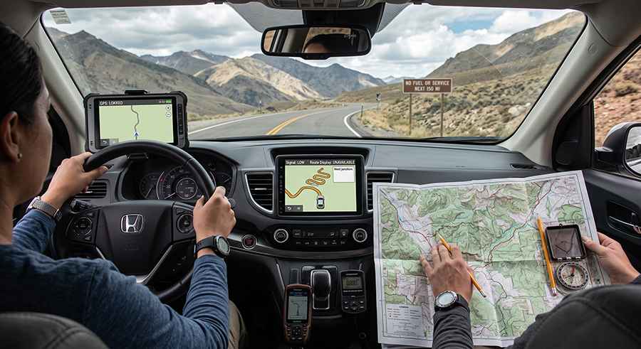
The answer is not to trust one device more fiercely. It is to build a navigation plan with several independent ways to understand where you are and what comes next.
This guide is for drivers planning a long rural journey, mountain crossing, or scenic route where a wrong turn has consequences. It covers map preparation, in-car systems, a separate backup, and the decisions that should be made before the vehicle moves. None of these tools can confirm that a road is open or safe today; current local information and the driver's judgment remain essential.
Research the road before drawing a line through it
A navigation app may display a road that exists on a map but is unsuitable for your vehicle. Look beyond the route preview. Check the road authority or park service for closures, seasonal access, surface conditions, bridge restrictions, and any permit requirements. Where the road crosses high ground, look at the weather forecast for the pass rather than only the towns at each end. A mild forecast in the valley says little about fog, snow, or wind higher up.
Write down the road numbers, major junctions, and the last reliable fuel stop. Identify a sensible turnaround point before any exposed or unpaved section. If the route includes a ferry, border, or gated road, confirm its operating hours. Save the source and the time of the check so that another driver can distinguish verified information from an old screenshot.
Prepare the in-car navigation system
Factory navigation can be a useful part of the plan because its screen has a fixed position and its map can remain available without a live mobile-data connection, provided the relevant map data is installed and the system is functioning. That does not mean every car has the same coverage or update method. Some use SD media; others need a download, activation, or service procedure.
Check the exact head unit, model year, map region, and installed version before looking for an update. A card that fits the slot is not necessarily compatible with the software or region in the vehicle. Record the part number shown on existing media where possible and compare it with the vehicle's documentation. If the system has never been used by the current driver, test a complete route near home, including voice guidance and recalculation after a harmless missed turn.
Owners comparing compatible navigation media and map options can review Navi World. Use the vehicle's system identification and region to check any listing; ask for confirmation if one of those details is uncertain. Do not make an update for the first time on the morning of a remote trip. Leave enough time to test it and resolve any activation or compatibility question.
Carry a backup that is genuinely independent
A second app on the same phone may be helpful, but it shares the same battery, screen, and charging cable. Download the full offline area before departure, including likely detours and the nearest larger towns. Open it while the phone is in airplane mode to confirm the map tiles and route are actually present. Save essential destinations such as fuel, lodging, medical services, and the planned exit from the remote section.
A paper road map adds a different failure mode. It can show the shape of the wider network when a screen is broken or a device loses power. Mark the intended route and the major alternatives in advance. Paper maps may be out of date, so use them for orientation, not as proof that an unmaintained track is passable. A charged power bank or 12-volt charger is useful, but should not be the sole answer to a dead phone.
Separate route guidance from road safety
A route engine optimizes a path according to its data and settings. It cannot reliably evaluate a washed-out bridge, a recent rockfall, deep snow, or whether your vehicle can clear a rut. A short suggested detour can be a much worse road. If guidance conflicts with signs, barriers, local authority notices, or conditions visible ahead, stop in a safe place and reassess. Never drive around a closure because a map continues to display the road.
Before entering a difficult segment, compare the route against what you researched. Verify the next few junctions and the point after which turning back becomes difficult. Set an arrival or check-in time with someone outside the vehicle, and tell them the intended route and when to raise concern. In particularly isolated places, a satellite communication device may be appropriate, but it requires its own setup and testing.
Reduce decisions while the car is moving
Set the destination, map scale, and voice volume while parked. If the route changes, ask a passenger to review it or stop before interacting with the screen. Avoid zooming or searching while negotiating narrow corners. The driver's attention belongs to the road, surrounding traffic, and conditions ahead.
At each planned stop, make a brief comparison: current location, next fuel opportunity, remaining daylight, weather, and whether the intended road is still open. This small routine catches mistakes before they accumulate. If progress is slower than expected, abandon the ambitious section while there is still a safe alternative. A successful journey is one that leaves room for a conservative decision.
A compact departure checklist
- Confirm the route's current status with the relevant road or park authority.
- Check weather for the highest and most exposed parts of the route.
- Test the car's installed navigation map and enter the destination before driving.
- Download and test an offline map that includes detours, not only the planned road.
- Carry a paper map and note key junctions, fuel stops, and turnaround points.
- Tell a trusted contact the route and expected check-in time.
- Keep enough fuel, water, and daylight margin to turn back if conditions change.
Good navigation is a chain of small checks. Updated map data, a tested backup, current road information, and a willingness to turn around each solve a different problem. Together they make a remote drive easier to understand without pretending that the line on a screen can replace conditions on the ground.