Off-Road GPS Tracker: Survive World’s Most Dangerous Roads
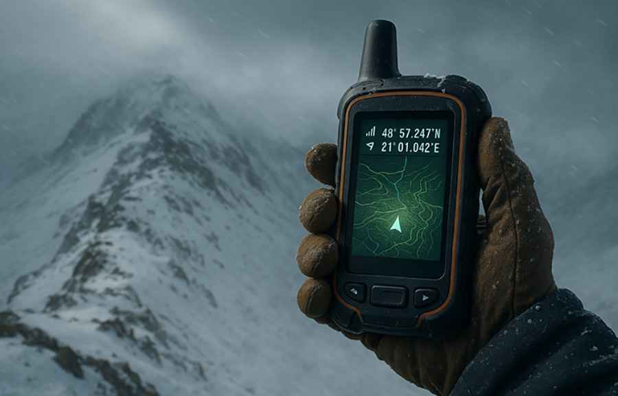
Somewhere high in the Andes, the dirt track fades into fog. The wind howls through the ravine, the cliffs rise like walls, and your phone shows nothing but a gray screen. Out here, there’s no Wi-Fi, no mobile towers, only rock, sky, and silence. This is the world’s dangerous roads, lonely mountain passes, jungle trails, and desert tracks where “off-grid” isn’t a travel choice; it’s a reality. And when every turn could lead to nowhere, an off-road GPS tracker isn’t a gadget; it’s your lifeline, and the GPS role is as a hero.
Why GPS Trackers Matter on Dangerous Roads
On remote mountain passes and forgotten desert trails, ordinary navigation tools quickly become useless.
These are places where the road narrows to a rocky ledge, where fog swallows the path ahead, and where a single wrong turn can take you miles off course. In such conditions, getting lost isn’t an inconvenience; it is a real danger.
That’s where off-road GPS trackers prove their worth. Unlike regular navigation apps that depend on cell towers, these rugged devices lock onto satellites orbiting high above the Earth. They trace your every move, mark your trail, and guide you back when landmarks vanish into dust or snow. Even in the middle of nowhere, they quietly record your route, keeping a digital thread between you and safety.
When the guardrails disappear and the world turns wild, a GPS tracker becomes more than technology; it’s your compass, your memory, and your lifeline when everything familiar fades away.
How Off-Road GPS Trackers Work
At their core, these devices are remarkably simple yet powerful. They don’t rely on cell towers or mobile data. Instead, they communicate directly with satellites orbiting thousands of kilometers above Earth. By locking onto multiple satellite signals at once, they can pinpoint your exact position, even when you’re deep inside a canyon, crossing a glacier, or under a dense forest canopy.
Unlike standard navigation apps, waterproof GPS trackers for offroading are built for the world’s wild places. They continue to operate when the network ends and the horizon stretches empty.
Most modern trackers go far beyond basic coordinates.
- Record your trail: Leave a digital breadcrumb path so you can retrace your steps even in total whiteout or darkness.
- Share your live location: Keep family, teammates, or rescue services updated in real time with a steady lifeline of coordinates that tells the world where you are, even when you’re days away from the nearest road. It’s the difference between being alone in the wild and being safely tracked across it.
- Download detailed topographic maps: Access elevation lines, terrain shapes, and off-grid routes without any internet signal.
- Send emergency SOS alerts: Connect through global satellite networks to summon help instantly, anywhere on the planet.
- Mark waypoints: Save key spots like water sources, rest camps, or escape routes for future reference; every landmark that could mean safety or supplies when the terrain turns unpredictable. From a hidden stream in the desert to a narrow pass through the mountains, these digital markers become your personal survival map when the landscape refuses to offer directions.
- Track performance data: Monitor altitude, speed, and distance to better understand your route and conditions.
These devices come in different forms:
- Handheld units: For trekkers and climbers.
- Dashboard-mounted systems: For off-road vehicles and overlanders.
- Compact satellite messengers: Small enough to clip to a backpack or bike.
Choosing the Right Off-Road GPS Tracker
Not all GPS trackers are built for extremes. If your journey crosses freezing summits, rain-slick jungle paths, or sun-scorched dunes, you need a device that can survive everything nature throws your way. Out here, fragile tech doesn’t last; only the tough gear does.
Look for:
- Satellite connectivity: Choose a tracker that communicates directly with global satellite networks, not cell towers. This ensures your signal stays strong even in deep valleys, dense forests, or across oceans of sand where no phone service exists.
- Durability: Go for a unit that’s shockproof, waterproof, and dustproof, tested to military or expedition-grade standards.
When you drop it on a rock, submerge it in a river, or drag it through sandstorms, it should keep working without hesitation.
- Battery life: Aim for at least a maximum of hours of continuous tracking or several days in standby mode. Long expeditions demand a device that lasts through freezing nights and scorching afternoons without frequent charging stops.
- Offline maps: Because “searching for a network” isn’t an option on a cliff road.
Make sure your tracker supports detailed offline topographic maps so you can navigate through mountains, deserts, or forests with total independence from mobile data.
- SOS capabilities: Look for built-in emergency alert systems that send distress signals directly to satellite rescue networks. In a crisis, one button should connect you to help even when every other form of communication is gone.
Top Off-Road GPS Trackers for Extreme Adventures
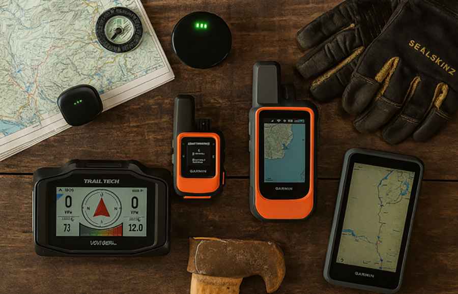
Here are a few rugged GPS trackers for hiking and trusted by explorers, overlanders, and rescue teams:
SpaceHawk GPS Tracker
Compact, durable, and fiercely dependable, the SpaceHawk GPS Tracker is built for explorers who venture far beyond the signal zones. This magnetic, waterproof tracker delivers real-time satellite precision in the world’s harshest terrains, from rocky desert trails to fog-covered mountain passes.
With advanced 4G GPS technology and a rugged, weatherproof casing, it clings securely to off-road vehicles, ATVs, or overland rigs without losing connection. Track your movement, mark key waypoints, and receive instant location updates through its easy-to-use mobile app, all while staying completely off-grid.
The SpaceHawk’s rare blend of size, strength, and stealth makes it a trusted companion for adventurers who value both accuracy and endurance. Whether you’re weaving through jungle tracks or tracing your route back across a canyon, the SpaceHawk keeps your position locked, no signal required, and no second-guessing your path.
Garmin inReach Mini 2:
Tiny but mighty. This pocket-sized satellite communicator proves that size doesn’t limit strength. It connects you to the Iridium satellite network, letting you send two-way messages and SOS alerts from literally anywhere on Earth, mountaintops, glaciers, or deep desert valleys.
Its long battery life, lightweight build, and ability to pair with your smartphone make it a favorite for bikers, trekkers, and solo travelers who venture beyond the edges of connectivity.
When all signals vanish, the Mini 2 keeps you visible.
Trail Tech Voyager Pro:
Designed for off-road vehicles and motorcycles, this tracker blends adventure with precision.
It doesn’t just record your route and monitor speed; it creates a shared digital map of your entire ride. The Buddy Tracking feature allows you to see where your fellow riders are in real time, adding both safety and fun to group expeditions. With its color touchscreen, GPS mapping, and rugged construction, it thrives in mud, heat, and chaos.
For riders who live by throttle and trail, the Voyager Pro is as essential as a helmet.
Garmin Montana 700i:
Built to survive dust, ice, and chaos, the Montana 700i combines detailed mapping, two-way messaging, and SOS functionality in one powerhouse device.
Its robust casing withstands extreme vibration and weather, while its 5-inch touchscreen stays responsive in rain or with gloves on.
Whether you’re crossing tundra, scaling a pass, or navigating forest tracks, it keeps your bearings clear and communication constant. With preloaded topographic maps and access to multiple satellite systems (GPS, GLONASS, and Galileo), the 700i ensures accuracy when the world below blurs into wilderness.
These are not just devices; they’re digital co-pilots that don’t panic when the map disappears, guiding you safely through the world’s wildest and most unpredictable roads.
Tips for Using GPS Trackers on Dangerous Roads
Even the best technology needs a smart traveler behind it. Out here, mistakes can cost you daylight, or worse. Preparation, awareness, and respect for the terrain make the real difference.
- Preload maps before leaving signal zones: Download every route, contour, and waypoint you might need before your signal fades. Remote valleys and high passes rarely offer reception, and a blank map screen is the last thing you want to see when the trail splits.
- Carry spare power banks or solar chargers: A dead battery can turn your GPS into dead weight. Carry multiple charging options, solar panels for long expeditions, and rugged power banks sealed against dust and moisture.
- Mark fuel points, water sources, and shelters before you start: Identify critical survival points along your route. A marked well, fuel stop, or safe shelter can make all the difference if plans change or weather closes in unexpectedly.
- Share your live tracking link with someone before you vanish into the wilderness: Let a trusted contact follow your journey in real time. If you go silent, they’ll know where to start looking. Rescue teams can’t help if no one knows where you were last seen.
- Trust your instincts: GPS can tell you where you are, but not whether the ground beneath you is crumbling or the storm ahead is impassable. Technology supports judgment; it doesn’t replace it.
Real Stories from the Edge
In 2023, a solo rider tackling Bolivia’s remote Uyuni salt flats hit an unexpected storm. Within minutes, visibility dropped to near zero, a blinding wall of white stretching in every direction. His off-road GPS tracker became his only lifeline, guiding him back toward a marked waypoint where rescue teams could reach him. He was found cold, but alive.
That same year, two travelers in Death Valley trusted a regular smartphone map for navigation. It led them down an unmaintained trail that faded into sand and silence. With no signal and no backup navigation, they spent two nights stranded before being discovered by chance.
The difference wasn’t bravery; it was preparation. The right gear, used wisely, turns danger into survival.
Trust the Tech, But Respect the Terrain
An off-road GPS tracker is more than a gadget; it’s a partner for every explorer who dares to drive where maps end. It’s the bridge between danger and discovery, between fear and freedom.
But remember, technology can guide you, not protect you. The mountains still command respect. The deserts still demand preparation.
When you roll onto a road carved into cliffs or vanish into a sea of sand, remember this: your GPS might be your last connection to the world. Treat it like the lifeline it is. Because on the world’s most dangerous roads, courage keeps you moving, but navigation keeps you alive.
FAQ
What makes an off-road GPS tracker different from a regular GPS or phone navigation app?
Off-road GPS trackers don’t rely on mobile data or cell towers.
They communicate directly with satellites, so they keep working in remote deserts, mountain ranges, or jungles where smartphones lose signal. Most also include SOS functions, offline maps, and weather-resistant designs made for real-world survival, not city streets.
Can off-road GPS trackers work without internet or phone service?
Yes, that’s exactly what they’re designed for. They use satellite connections instead of mobile networks, which means they can pinpoint your position and guide you even hundreds of kilometers beyond the nearest signal.
As long as the device has a clear view of the sky, it can track and communicate anywhere on Earth.
Which off-road GPS tracker is best for extreme travel or dangerous terrain?
For 2025, top-rated devices include:
- Garmin Overlander: Best for vehicle-based expeditions.
- Garmin inReach Mini 2: Ideal for solo travelers and hikers.
- Trail Tech Voyager Pro: Perfect for off-road bikes and ATV riders.
- Garmin Montana 700i: The all-rounder for multi-day adventures. The right choice depends on your activity, terrain, and whether you need communication or just navigation.
How can I stay safe using a GPS tracker on dangerous roads?
Technology helps, but planning saves lives. Always preload your maps, mark fuel and water points, carry spare power sources, and share your live location with someone before heading out.
Trust your instincts when the terrain looks unstable; even the best satellite connection can’t sense a collapsing cliff or flash flood.
What features should I look for in an off-road GPS tracker for adventure travel?
Choose one built for endurance and reliability. Look for:
- Satellite connectivity (not dependent on cell signal)
- Long battery life (30+ hours or more)
- Durability (shockproof, waterproof, dustproof)
- SOS capability with satellite rescue networks
- Offline topographic maps for navigation without data and These essentials separate professional-grade trackers from consumer gadgets.