Garden Route to Sani Pass: South Africa’s Most Thrilling Drives (and How to Stay Online the Whole Way)
South Africa packs more wow-per-mile than just about anywhere on earth, but two stretches of asphalt (and gravel!) turn a simple road trip into legend: the lush Garden Route on the south-eastern coast and the vertigo-inducing Sani Pass that twists up the Drakensberg into Lesotho. This guide stitches them together into one epic adventure—and shows you exactly how an eSIM for South Africa keeps your maps, weather apps, and brag-worthy Insta-stories live even where cell towers are scarce.
Why These Two Roads Belong on Your Bucket List
- Iconic Variety – From sea-spray cliffs and indigenous forest canopies to 9,400-foot alpine switchbacks.
- Accessibility – The Garden Route is paved perfection; Sani Pass demands a 4×4 but no special permits for U.S. or Canadian tourists.
- Wildlife Hotspots – Think breaching humpbacks near Plettenberg Bay and grazing eland on the escarpment.
- Year-Round Appeal – Mild oceanic climate on the coast; crisp mountain summers and snowy winter scenes in the high Drakensberg.
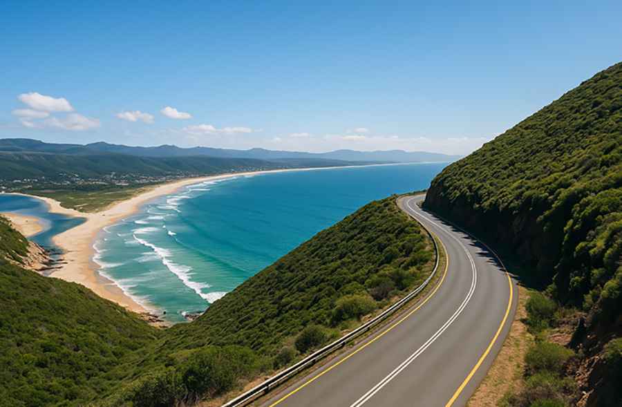
The Garden Route – Coastline Meets Rain Forest
What Makes It Special?
The Garden Route’s paved N2 highway hugs the Indian Ocean for roughly 300 km, running from Mossel Bay to Storms River and threading past lagoons, vineyards, and fynbos-covered mountains. Mild temps (rarely above 82 °F or below 50 °F) and year-round rain keep everything impossibly green
Must-Stop Highlights
Kilometer Marker | Stop | Why Pull Over |
0 km – Mossel Bay | Diaz Museum & Point Lighthouse | 1488 maritime history and shark-cage diving |
110 km – Knysna | Featherbed Nature Reserve | Lagoon ferry, sea-horse research center |
160 km – Plettenberg Bay | Robberg Peninsula Trail | Cliff-edge boardwalks, Cape fur seal colony |
210 km – Nature’s Valley | Bloukrans Bridge | World’s highest commercial bungee (709 ft) |
300 km – Storms River | Tsitsikamma National Park | Suspension bridge over black-water gorge |
Driving Tip: Google’s offline maps lose detail under the forest canopy near Nature’s Valley. Before you roll, preload that segment—or better yet, rely on an eSIM for South Africa so turn-by-turn audio never drops.
Sani Pass – A Dirt Ribbon to the Sky
From Underberg, KwaZulu-Natal, a dusty track (P318) claws 4,300 ft skyward in just 20 km, topping out at 9,436 ft (2,876 m) on Sani Pass, at the Lesotho border.
Switchbacks so tight they look scribbled on a topo map deliver stone-house border posts, Basotho shepherds, and the self-proclaimed “Highest Pub in Africa.”
4×4 Basics
- Gear Low, Go Slow. Most hairpins hit gradients of 1:4; first gear is your friend when descending.
- Weather Windows. June–August snowfall can close the pass without warning—check SAPS Twitter feeds the night before.
- Border Hours. 6 a.m.–6 p.m.; no visa for U.S./Canadian passport holders staying under 14 days.
- Tire Pressures. Drop to ~1.6 bar on loose gravel for grip, but reinflate in Lesotho’s thin air before heading onward to Mokhotlong.
Staying Connected Where Cell Towers Fear to Tread
South Africa’s coastal N2 offers 4G most of the way, but inland switchbacks and Tsitsikamma’s cliffs can leave you on “SOS.” Traditional roaming packages from U.S./Canadian carriers cost upward of $10/day and still cut to 2G speeds after a gigabyte or two.
To stay truly online, find out more about installing a prepaid digital eSIM for South Africa that jumps between Vodacom, MTN, and Cell C—three networks in one QR code. You activate it as you cross the border (or right at Cape Town International if you’re flying in), track data in an app, and top up if your drone-video habit snowballs mid-trip.
Sample 10-Day Itinerary
Day | Morning | Afternoon | Overnight |
1 | Cape Town pick-up | Drive to Mossel Bay (4.5 hrs) | Mossel Bay |
2 | Diaz Museum | Surf lesson at Victoria Bay | Wilderness |
3 | Knysna lagoon kayak | Sunset at Brenton-on-Sea | Knysna |
4 | Robberg hike | Wine-tasting in Plettenberg | Plettenberg |
5 | Tsitsikamma treetop zipline | Bungy off Bloukrans | Storms River |
6 | Inland detour via Route 62 | Ostrich farm in Oudtshoorn | Oudtshoorn |
7 | Swartberg Pass gravel drive | Arrive Underberg | Underberg |
8 | Sani Pass ascent | Lunch at Highest Pub | Lesotho border lodge |
9 | Return via Sani | Hike Drakensberg’s Giant’s Cup | Underberg |
10 | Drive Durban (2.5 hrs) | Indian-Ocean beach day | Depart |
Leave-No-Trace & Safety Nuggets
- Mind the Baboons. They know how to open backpacks—lock windows at viewpoints.
- Road Shoulders Are Soft. On the N2, stop only at paved pull-outs; sandy edges swallow tires.
- Fire Danger. Fynbos burns hot and fast; follow local fire-ban signage.
- Altitude Adjustment. At nearly 3,000 m Sani’s summit can trigger mild AMS—hydrate and ascend slowly.
- Respect Pass Closures. Tourist 4×4 recoveries cost up to R10,000; if police close the gate, believe them.
Final Thoughts
Pairing the Garden Route’s blue-green coastline with Sani Pass’s high-alpine drama turns a classic South African holiday into a badge-of-honor adventure. And with a pocket-friendly eSIM for South Africa running your maps, livestreams, and border-control QR codes, you’ll spend less time hunting Wi-Fi and more time chasing whale tails, surf breaks, and hairpin bends.
Fill the tank, drop the tire pressure, and hit the road—Africa’s most photogenic sea-to-sky drive is waiting. Safe travels and keep the rubber side down!