What are the highest roads in the world? Top 25
Determining the highest road on Earth is an arduous task, primarily due to the ambiguity surrounding the term 'road' itself. Does it refer to a treacherous mountain pass accessible only to skilled drivers with specialized vehicles? Or does it signify a pathway exclusively suited for bicycles or motorcycles? Alternatively, should we consider a mountain road that can be traversed by an average driver with a regular vehicle?
Consequently, defining the world's highest road becomes an intricate challenge. The quest for the world's highest bikeable roads is primarily characterized by the absence of clear-cut altitudes for the respective routes. Extensive literature, maps, and online information present a multitude of results, often marred by doubt and conflicting claims.
What is the highest road in the world?
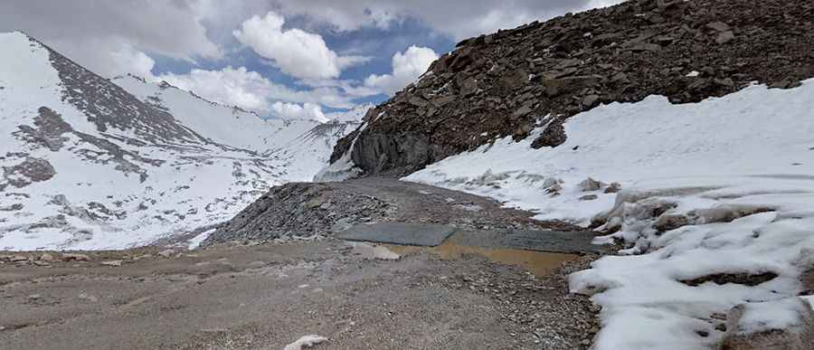
It is evident and widely acknowledged that the road to Khardung La, situated in the Indian Himalayas at an altitude of 5,359m (17,582ft), is not the highest road on Earth. Despite the prevailing misconceptions perpetuated by the Guinness World Records, numerous misinformed websites, and even the signage at the mountain's peak claiming it to be the world's highest road with an elevation of 5,682m (18,641ft), recent GPS measurements have revealed that even this reported altitude is inaccurate.
What is the highest road in Asia?
Within the same country, there exist significantly higher mountain passes. One such example is the Umling La, a recently constructed paved road located in the state of Jammu and Kashmir, renowned as the "top of the world" at an impressive elevation of 5.818m (19,087ft) above sea level. Umling La is officially recorded at 5,798m (19,024ft) by the Guinness World Records. However, numerous independent GPS measurements by high-altitude travelers consistently show elevations between 5,818m and 5,882m, suggesting it might be even higher than officially recognized.
Additionally, the road leading to Kiu La, an international mountain pass situated on the border between India and China, reaches a peak elevation of 5,711m (18,736ft). However, the true behemoth of the region might be the road ascending Chāmkang mountain, reaching a staggering height of 5,953m (19,530ft) in the disputed region of Aksai Chin, situated on the Chinese-Indian border. This road, an aged jeep track running parallel to the Indian border, is strictly military due to its uninhabited nature and its history as a conflict zone.
On the Chinese-Indian border, there is a gravel road that reaches an elevation of 5,844m (19,173ft) above sea level at the summit of Khungyami La. Similarly, an unpaved road ascends to the peak of Kungzhag La, a mountain summit at 5,780m (18,963ft) above sea level. Additionally, a recently constructed unpaved road in close proximity to the Chinese-Indian Line of Control leads to Wenquan Daban (Hot Springs Daban) at an elevation of 5,808m (19,055ft) above sea level.
In the disputed area between India and China, a new unpaved road has been built, reaching an elevation of 5,795m (19,012ft) above sea level at the summit of Lungar La. Moreover, a treacherous road on the Chinese-Indian border climbs to Lungmar La, situated at 5,776m (18,950ft) above sea level. Notably, although there are roads on both sides of the border, they do not meet at the summit. This region also hosts various military high mountain roads.
A recently constructed road in 2021 connects India and China through Medo La, which culminates at a remarkable height of 5,915m (19,406ft) above sea level.
In a remarkable endeavor, the Border Roads Organisation (BRO) constructed the 'Likaru-Mig La-Fukche' road in Ladakh's Demchok sector. Completed in October 2025, it is officially the world's highest motorable road, reaching an elevation of 5,913m (19,400ft) above sea level at Mig La, surpassing the previous record held by Umling La.
What is the highest road in China?
In China, the landscape undergoes a dramatic transformation, and accessing certain border areas becomes an immense challenge. Consequently, the certainty of traversing the highest mountain roads in the country remains shrouded in mystery, relying on sources of doubtful credibility. However, amidst this intrigue, a newly constructed road ascends to the international Kiu La, boasting an awe-inspiring elevation of 5,711m (18,736ft) above sea level.
There are accounts suggesting that vehicles may have conquered the lofty heights of Lajiong La at 5,830m (19,127ft), Jang Rang La at 5,793m (19,005ft), Kye La (also known as Kyen La) at 5,829m (19,124ft) between the villages of Gyirong and Changguoxiang, and Bodpo La at 5,774m (18,943ft). However, the feasibility of driving to the summits of these mountain passes remains highly questionable. It remains unclear if they are truly motorable in a sense that the majority of drivers and vehicles could undertake. Among them, Lajiong La appears to be the most reliable, with photographs showcasing 4x4 vehicles at its pinnacle. As for the other two passes, there are snapshots of bicycle ascents, but reliable information about motor vehicles is lacking.
Tibetan road maps hint at the existence of even higher mountain passes, but their accessibility remains uncertain. Some sources mention the possibility of a towering giant called Gorun La, reaching a staggering elevation of 5,910m (19,389ft), yet its existence seems dubious. Satellite images do not confirm if the road is wide enough for vehicles to pass through, but it is evident that the only route near the peak concludes at approximately 5,690m (18,667ft).
Venturing further into the realm of high-altitude journeys, a remote military road known as Tiankong Way ascends to Yiyepusangla Daban, perched at an impressive 5,886m (19,311ft) above sea level. Constructed in 2016, this route stands tall in the Himalayan mountain range within the Ngari Prefecture. Another road leads to the summit of Buduo Peak, nestled in the Tibetan Plateau, at an elevation of 5,825m (19,110ft) above sea level.
Ascending to lofty heights on the Tibetan Plateau, a rugged 4x4 road guides explorers to the captivating Changlung and Aruo lakes, cresting at Zǔsōng La at 5,775m (18,946ft) above sea level. The Chinese region is further punctuated by Yangi Daban, a colossal climb reaching a formidable 5,899m (19,353ft) above sea level. Meanwhile, a narrow road ascends to Mobdi La at 5,788m (18,989ft) above sea level, and a road constructed in 2017 leads to the zinc and lead deposits of Huoshaoyun, peaking at 5,765m (18,914ft) above sea level.
What is the highest road of Europe?
Embark on an exhilarating expedition through Europe's highest roads, where breathtaking altitudes beckon the adventurous at heart. In Russia, an extraordinary dirt track leads intrepid explorers to the crown of the continent's highest road: Mount Elbrus at 5,642m (17,919ft) above the sea level. this treacherous route is exclusively reserved for specially prepared vehicles, offering an unparalleled experience for those seeking to conquer Russia's majestic peaks. On the same range, a road leads to Gara-Bashi station, a ski lift at an elevation of 3.883m (12,739ft) above the sea level.
Further west, Veleta Peak in Spain proudly showcases the continent's highest paved road. Reaching a stunning height of 3,394m (11,135ft) above sea level, this meticulously maintained road invites travelers to immerse themselves in the awe-inspiring Spanish landscapes while relishing the thrill of conquering Europe's lofty heights.
What is the highest road in the USA?
Embarking on an exhilarating expedition through North America, a multitude of roads ascend to heights exceeding 14,000 feet. These majestic roads lead adventurers to some of the continent's most renowned peaks, offering thrilling experiences and awe-inspiring vistas. Standout among these majestic "fourteeners" is the White Mountain Peak, reaching an impressive elevation of 4.347m (14,261ft) above sea level. This gravel road ascent beckons intrepid explorers to test their mettle against the rugged terrain and embrace the challenge of conquering this towering summit. Another prominent peak is Mount Bross, proudly standing at an impressive 4.071m (13,356ft) elevation. Accessed via a gravel road, this daring climb presents adventurers with a thrilling opportunity to scale its majestic heights and bask in the glory of their accomplishment. For those seeking an unforgettable journey on a paved road, the steep climb to Mount Evans awaits. Reaching its pinnacle at a breathtaking elevation of 4.310m (14,130ft) above sea level, this well-maintained road promises panoramic vistas and a sense of triumph as you reach the summit.
What is the highest road of South America?
South America is a continent where determining the highest drivable roads can be confusing. It becomes essential to clarify whether a road is accessible by regular vehicles or only suited for bicycles or highly adapted vehicles. The true identification and location of the highest motorable pass depend on the definition of a "motorable pass."
Evidence exists of a Spanish team's ascent to the summit of Aconcagua in Argentina in 1977, reaching an impressive altitude of 6,961m (22,838ft), setting a motorcycle altitude record. However, it's important to note that this route was not a road, and the team utilized specially adapted motorcycles. Along the Chile-Argentina border, Ojos del Salado, a volcano rising to 6,891m (22,608ft) above sea level in the Atacama Desert, has attracted drivers seeking to break altitude records in motor vehicles. Nevertheless, these vehicles were specially modified, and there isn't a clearly defined road to the summit.
In northern Chile, there was once a sulfur mine on the Aucanquilcha stratovolcano, reaching a height of 6,176m (20,262ft) above sea level, accessible by motor vehicles. However, after the mine ceased operations, landslides rendered the road to the summit impassable. Similarly, Cerro Uturuncu, one of the continent's highest volcanoes, stands at 6,008m (19,711ft). A road existed to the top in the past, providing access to a mine. However, with the mine's closure, the road fell into disuse and is now partially passable due to a landslide at 5,500m (18,044ft) above sea level. Despite this, a French team recently reached near the summit on mountain bikes.
Another accessible point on the continent, reachable by vehicle, is the mountain refuge known as Refugio Tejos in Chile, situated at an elevation of 19,000ft (5,800m) above sea level. It can be reached via a 4x4 mountain track. Slightly lower in elevation is the Ollagüe Volcano, standing at 5,868m (19,251ft) on the Chile-Bolivia border. The road abruptly ends at 5,705m (18,717ft) above sea level and is a 4x4 route but can be hindered by rock collapses and landslides.
On the Chile-Bolivia border, there is an abandoned mining dirt road that ascends to 5,753m (18,874ft) above sea level, leading to a mountain outpost near the summit of Cerro Sairécabur. The journey on this road is particularly challenging and demanding. On the same border, an abandoned mining road climbs up to Putana Volcano, at 5.779m (18,959ft) above the sea level. The volcano has large sulfur deposits.
Highest Motorable Points in the world:
| Mountain road | Elevation | Country |
|---|---|---|
| Ojos del Salado | 6.688m (21,942ft) | Argentina–Chile. Altitude Record (No road) |
| Chāmkang mtn. | 5.953m (19,530ft) | China |
| Medo La | 5.915m (19,406ft) | India–China |
| Mig La | 5.913m (19,400ft) | India |
| Yangi Daban | 5.899m (19,353ft) | China |
| Tiankong Way | 5.886m (19,311ft) | China |
| Khungyami La | 5.844m (19,173ft) | India–China |
| Lajiong La | 5.830m (19,127ft) | China |
| Kye La | 5.829m (19,124ft) | China |
| Buduo | 5.825m (19,110ft) | China |
| Umling La | 5.818m (19,087ft) | India |
| Wenquan Daban | 5.808m (19,055ft) | India–China |
| Lalung Valley Rd | 5.803m (19,038ft) | India–China |
| Refugio Tejos | 5.800m (19,000ft) | Argentina–Chile |
| Lungar La | 5.795m (19,012ft) | India–China |
| Jang Rang La | 5.793m (19,005ft) | China |
| Mobdi La | 5.788m (18,989ft) | China |
| Kungzhag La | 5.780m (18,963ft) | India–China |
| Putana Volcano | 5.779m (18,959ft) | Chile–Bolivia |
| Lungmar La | 5.776m (18,950ft) | India–China |
| Zǔsōng La | 5.775m (18,946ft) | China |
| Bodpo La | 5.774m (18,943ft) | China |
| Huoshaoyun | 5.765m (18,914ft) | China |
| Cerro Uturuncu | 5.760m (18,897ft) | Bolivia |
| Cerro Sairécabur | 5.753m (18,874ft) | Chile–Bolivia |
| Nilung La | 5.730m (18,799ft) | India–China |
| Kiu La | 5.711m (18,736ft) | China–India |
| Ollagüe Volcano | 5.705m (18,717ft) | Chile–Bolivia |
Highest roads on Earth (by country):


Pic: Saurabh Arora