Spreetshoogte Pass is one of the steepest (14%) roads in Namibia
Spreetshoogte Pass is a high mountain pass at an elevation of 1,822m (5,977ft) above sea level, located in the Khomas region of Namibia. It’s one of the highest roads in the country.
Where is Spreetshoogte Pass?
The pass is located in the central part of the country and connects the Namib Desert with the Khomas Highland.
Why is it called Spreetshoogte Pass?
The pass is named after farmer Nicolaas Spreeth.
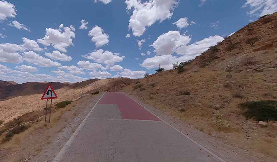
Is Spreetshoogte Pass paved?
The road to the summit is mostly unpaved. It has concrete sections on the steepest parts. It’s called D1275.
How long is Spreetshoogte Pass?
The pass is 50.4 km (31.31 miles) long, running from Solitaire, near the Namib-Naukluft National Park, to Nauchas, on the D1261 road.
Is Spreetshoogte Pass steep?
Hitting a 14% maximum gradient through some of the ramps, it’s one of the steepest passes in southern Africa, descending almost 1,000 meters (3,300 ft) within 4 kilometers (2.5 mi) of road. As such, it is a little trickier to drive.
How dangerous is Spreetshoogte Pass?
The descent is very dangerous in order to keep the danger of failing brakes to a minimum. It’s passable only for vehicles without trailers. Trucks and caravans are forbidden to use it. The sharp bends and steep gradients are not good news for intrepid explorers.
Is Spreetshoogte Pass worth it?
To drive the road without stopping will take most people between 45 and 60 minutes. The drive offers unrivaled views of the dramatic landscape below the pass. The top of the pass has a viewpoint affording scenic views of the Namib Desert.
When is the best time to drive through Spreetshoogte Pass?
It is best to drive in the afternoons as the landscape in the later afternoon sun is truly gorgeous and offers some awesome photographic opportunities.
Pic: Map Your Town