R704: Conquering Morocco's Toughest Road in the High Atlas
The R704 is widely considered one of the most technical and high-altitude roads in the High Atlas Mountains of Morocco. Reaching a maximum elevation of 2,910 meters (9,547 feet), this trans-mountain route connects the lush Dadès Valley with the remote northern plateaus. It is a legendary track for off-roaders, transitioning from scenic asphalt gorges to a high-risk gravel "piste".
| Road facts: R704 Morocco | |
|---|---|
| Location | Tinghir Province, Morocco |
| Max Elevation | 2,910 m (9,547 ft) at Tizi-n'Ouano |
| Length | 122 km (76 miles) |
| Surface | Paved (70km) / Unpaved Piste (52km) |
Where is the R704 road located?
The road is situated in the Tinghir Province within the Drâa-Tafilalet region. It serves as a vital but primitive link across the central High Atlas, running south to north from Boumalne Dades to Agoudal. The route starts by crossing the famous Gorges du Dadès, where the landscape is characterized by red rock formations and traditional fortified Kasbahs.
Is the R704 road paved?
The R704 offers two very different driving experiences. The first 70 kilometers from Boumalne Dades are asphalted, allowing for standard vehicle travel through the gorges. However, the final 52 kilometers to Agoudal remain an unpaved "piste". This section is a rugged track consisting of loose gravel, hard-packed dirt, and sharp stones. A high-clearance 4x4 vehicle is mandatory for this stretch, as the road surface deteriorates quickly with altitude and weather.
How many passes does the R704 cross?
This is one of the highest roads in Morocco, staying entirely above 1,600 meters. The R704 climbs over several significant mountain passes:
- Tizi-n'Ouano: The highest point at 2,910m (9,547ft).
- Tizi n’Bou Oudi: Reaching 2,794m (9,166ft).
- Jebel Ouamenzri: Sitting at 2,583m (8,474ft).
Due to these elevations, the road is not plowed in winter and is frequently blocked by heavy snow from November to April.
How challenging is the R704 road?
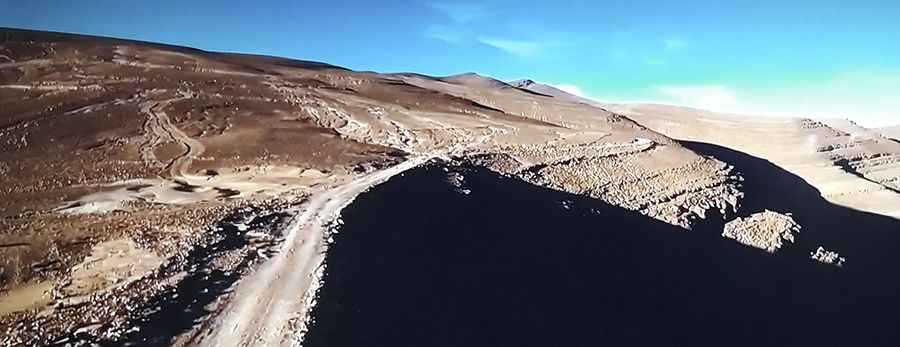
The technical difficulty increases significantly once the pavement ends. The track becomes a series of unbarriered off-road hairpins with sheer drops of hundreds of meters. Much of the route is single-track, meaning meeting oncoming traffic requires one driver to find a passing pocket or reverse on a narrow ledge. A specific hazard to watch for is a large section of sticky clay near the higher elevations, which becomes a trap after rain. Flash floods in the lower gorges and rockfalls on the upper slopes are the primary environmental risks.
When is the best time to drive the R704 road?
The best window for the full crossing is from late May to September. During this time, the high passes are clear of snow. If you are only visiting the lower Dadès Valley, March to May offers the best temperatures. Always start the 122 km journey with a full tank of fuel and plenty of water, as there are no services once you leave the gorge area and head toward Agoudal.