Road to Tizi n’Tiferguine: Driving the 2,025m Unpaved Pass in Morocco
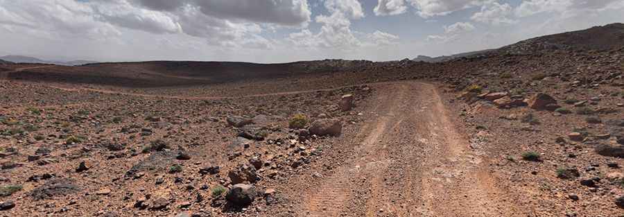
Located in the Drâa-Tafilalet region of Morocco, Tizi n’Tiferguine is a high mountain pass at an elevation of 2,025m (6,643ft) above sea level. Situated south of the High Atlas range, the pass serves as a remote unpaved corridor connecting isolated Berber settlements through a rugged, arid landscape.
| Road facts: Tizi n’Tiferguine | |
|---|---|
| Location | Drâa-Tafilalet, Morocco |
| Elevation Gain | 748 m |
| Length | 17.2 km (10.68 miles) |
| Average Gradient | 4.34% |
| Coordinates | 30.92734, -6.213 |
| Surface | Unpaved / Rocks and Sand |
How is the road to Tizi n’Tiferguine?
The ascent to Tizi n’Tiferguine starts from Akka Noughally. The road is 17.2 km (10.68 miles) long and is entirely unpaved. Over this distance, the track gains 748 meters in altitude, with an average gradient of 4.34%. While the average slope is moderate, the terrain is characterized by loose shale, sharp rocks, and sandy sections that can compromise traction. The track follows the natural contours of the mountain, featuring numerous unbanked curves and narrow passages where a high-clearance 4x4 vehicle is mandatory to avoid underbody damage.
What are the driving hazards on the Tizi n’Tiferguine track?
The primary hazards on this Moroccan pass are flash floods and extreme thermal stress. In the arid Drâa-Tafilalet region, sudden storms can turn dry oueds (riverbeds) into torrents that wash away sections of the 17.2 km track. The surface is subject to heavy erosion, creating deep ruts that require technical driving skills to navigate. Additionally, the lack of safety barriers and the presence of loose gravel on the outer edges of the road make the 2,025m summit approach particularly dangerous during high winds or low visibility conditions.
Is the road to Tizi n’Tiferguine open year-round?
Although the region is predominantly arid, the 2,025m elevation means that occasional snow can block the pass during the winter months (December to February). During the summer, the main risk is the extreme heat, which puts a significant load on the vehicle's cooling system during the 748m climb. There are no refueling or mechanical services available along the route; drivers must be fully self-sufficient with extra water, fuel, and specialized recovery gear for sandy and rocky terrain before leaving Akka Noughally.
What is the driving strategy for the 17.2 km ascent?
Navigating Tizi n’Tiferguine requires constant attention to the track surface. It is necessary to use low-range gearing in the sections where the loose rock reduces friction. On the descent, engine braking should be prioritized to maintain control on the unpaved surface and prevent overheating the brakes. Monitoring tire pressure is essential, as the sharp stones typical of the Anti-Atlas and South Atlas foothills are prone to causing punctures. Before attempting the crossing, verify the mechanical integrity of the suspension and steering components to handle the sustained vibrations of the 17.2 km unpaved stretch.
Pic: András POLGÁR