Tizi n' Tighart n'Miouine: The 2,890m unpaved climb in the High Atlas
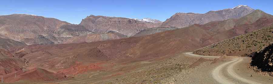
Tizi n' Tighart n'Miouine is one of the highest mountain passes of Morocco, reaching a significant elevation of 2,890m (9,481ft) above sea level. Located in the Ouarzazate Province, within the Souss-Massa-Drâa region, this pass represents the final, vertical push into the high peaks of the Atlas Mountains. The road is a raw, unpaved track that requires total mechanical focus and a high-clearance 4x4 to manage the loose surface and the thinning air at nearly 3,000 meters.
| Road facts: Tizi n' Tighart n'Miouine | |
|---|---|
| Location | Ouarzazate Province, Morocco |
| Max Elevation | 2,890m (9,481ft) |
| Length | 1.3 km (0.8 miles) |
| Average Gradient | 7.92% |
How challenging is the final 1.3-km climb from Tizi n'Oulaoun?
The journey to the summit starts at the already formidable Tizi n'Oulaoun. From this point, the road to Tizi n' Tighart n'Miouine is only 1.3 km long, but it packs a significant technical punch. The challenge of this final transit is the constant vertical gain; over this short distance, you climb 103 meters with an average gradient of 7.92%. Navigating this unpaved ramp requires maintaining a steady momentum, as the track is often covered in loose shale and crushed rocks that can make the tires spin and lose traction instantly on the steeper hairpins.
Why is the high-altitude air a factor for your 4x4 engine?
At an elevation of 2,890 meters, the atmospheric pressure is significantly lower than at the base of the Atlas. This thinning air reduces the oxygen intake of your engine, leading to a noticeable drop in power and an increase in operating temperatures. When combined with the low-speed, high-torque demands of the 7.92% gradient, your cooling system is under extreme stress. Professional drivers monitor their telemetry closely on this final 1.3-km stretch to avoid a boil-over. Maintaining a low gear and a disciplined velocity is the only way to ensure the mechanical integrity of the vehicle as you reach the summit.
What are the hazards of the unpaved surface near the summit?
The geography of Tizi n' Tighart n'Miouine is defined by its exposure to the elements. The road is totally unpaved and features deep ruts carved by seasonal meltwater. Because of the altitude, the ground is frequently frozen or saturated, making the red dirt surface highly unpredictable. The track is narrow, with steep unprotected drops on the shoulders that leave zero margin for steering errors. Flash floods and rockfalls are common in the Ouarzazate Province, often depositing large boulders on the driving line that require high clearance and careful maneuvering to bypass safely.
What mechanical preparation is needed for the Tizi n' Tighart n'Miouine transit?
Reaching the 2,890m summit is a task that demands total mechanical self-sufficiency. Before attempting this final climb, a full audit of your 4x4’s tires and suspension is mandatory. The sharp rocks of the High Atlas can easily compromise a sidewall, and the vibration of the unpaved surface can rattle components loose. Carrying recovery gear, extra water, and ensuring your battery is in peak condition is essential, as the isolation at this altitude means help is non-existent. This is a technical mountain drive where the driver’s ability to read the terrain and the vehicle’s low-range performance are the only guarantees of a safe descent.
Road suggested by: Hugh Wilson
Pic: Alberto Pedrotti