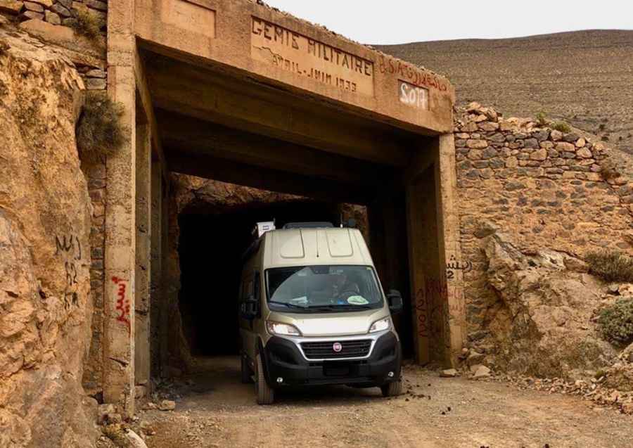
How to drive the helical tunnel of Tizi Tagountsa?
Tizi Tagountsa is a high-altitude mountain pass at an elevation of 2,226m (7,303ft) above sea level, located in the High Atlas range of Morocco. The route is famous for its unique helical tunnel, a military engineering project completed in 1933 by the French Foreign Legion to bypass the steep cliffs of Jebel Tagountsa (2,611m). The track, designated as the P7113, spans 45 km and connects the villages of Agoudim and Ait Sidi Mhamed, offering a complex logistical challenge due to its unpaved surface and extreme vertical exposure.
| Road facts: Tizi Tagountsa (P7113) | |
|---|---|
| Location | High Atlas, Morocco (Agoudim to Tizra) |
| Elevation | 2,226 m (7,303 ft) |
| Length | 45 km (28 miles) |
| Surface | Unpaved / Rocky track |
| Engineering Feature | 360-degree helical tunnel |
What is the engineering logistics of the Tizi Tagountsa tunnel?
The Tagountsa Tunnel is the only spiral tunnel in North Africa, designed to solve a 600-meter elevation gain within a restricted rocky face. Logistically, the track enters the mountain, executes a 360-degree internal rotation while descending, and emerges below the entrance facing the opposite direction. Built in 1933 by 3,000 workers—including the Foreign Legion and Moroccan Tirailleurs—the project required 5 tons of explosives and 50,000 liters of fuel. For modern drivers, navigating this 6-kilometer tunnel sector requires high-intensity lighting and a vehicle with high ground clearance to manage the uneven, rocky floor inside the unlit mountain shaft.
How to manage the unpaved logistics of the P7113 on Tizi Tagountsa?
The 45 km P7113 road is a completely unpaved track that crosses the Tagountsa massif. Logistically, the ascent from the plain involves a rapid 600-meter climb over a very short distance, testing the vehicle's cooling system and torque delivery. The surface consists of loose rocks and compacted earth, which can become impassable during the rare but intense Atlas rainstorms. Drivers must account for the lack of safety barriers along the cliffs, where the drop-offs range from 600 to 1,000 meters. A 4x4 vehicle with a low-range gearbox is a technical requirement to maintain traction on the steep, curvy sections leading to the tunnel entrance.
What are the driving hazards of the Tizi Tagountsa mountain pass?
Operating a vehicle on Tizi Tagountsa at over 2,200 meters requires constant attention to the "shelf road" conditions. The track is narrow, often allowing only one vehicle to pass, which necessitates a yielding protocol based on uphill priority. The rocky terrain puts extreme stress on tire sidewalls; logistically, carrying two full-sized spare tires and a high-lift jack is mandatory for this sector. Mechanical self-sufficiency is vital, as the track links isolated villages like Agoudim and Tana, where no technical assistance or fuel stations exist. The final descent towards the Amellago Gorges involves tight corners where engine braking is necessary to avoid brake overheating on the sustained rocky declines.
How does the history of Tizi Tagountsa affect its current logistics?
Originally constructed as a military strategic route for the final submission of Berber tribes in June 1933, the Tizi Tagountsa pass has seen minimal infrastructure updates over the last 90 years. Today, the track is practically disused and serves only local transit and off-road expeditions. Logistically, this means the path is subject to natural erosion and rockfalls that are not regularly cleared. Before attempting the P7113, drivers must verify the structural integrity of the bridges near Agoudim and ensure they have enough fuel for the 45 km transit, as the high-altitude, low-gear driving will double the standard fuel consumption rates.
Road suggested by: jorge manuel gómez sánchez
Pic: Harry Meidert