Likalaneng Pass: Driving the high-altitude A3 road in Lesotho
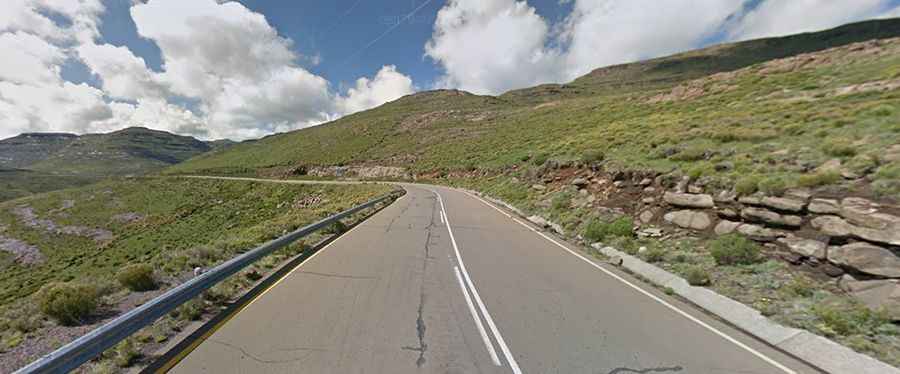
Likalaneng Pass is a high mountain pass at an elevation of 2,638 meters (8,654 ft) above sea level, located in the Maseru District of Lesotho. Positioned in the rugged central highlands of the Maloti Mountains, the route through the pass is the fully paved A3 highway, which forces drivers to manage tight basalt rock cuttings, severe engine power loss, and sharp unprotected drops.
| Road facts: Likalaneng Pass | |
|---|---|
| Location | Maseru District, Central Highlands, Lesotho |
| Elevation | 2,638 m (8,654 ft) |
| Route | A3 Highway |
| Length | 48.5 km (30.1 miles) between Marakabei and Fosi |
| Surface | Paved asphalt |
How challenging is the A3 road over Likalaneng Pass?
The 48.5-kilometer section of the A3 highway connects the mountain villages of Marakabei and Fosi. Although the entire route is paved with asphalt, the lane layout is tight and follows the natural twists of the basalt ridges. The tarmac is carved straight into the mountain walls, leaving vertical rock faces on the inner side and deep valleys on the outer edge with zero steel guardrails. The mountain asphalt is highly abrasive and suffers from extreme temperature changes. During winter, frozen mountain runoff creates wide sheets of black ice in the shaded corners that cause tires to spin out without warning.
Why do engines struggle with the altitude at Likalaneng Pass?
At an elevation of 2,638 meters, the thin mountain atmosphere starves vehicle engines of oxygen. This air density drop causes a major loss of torque, making the steep tarmac ramps much harder to climb than they appear on maps. The high altitude also triggers sudden mountain storms and thick banks of mist that roll over the ridges in minutes, dropping visibility down to a few meters. Because the white and yellow lane markings on many sections of the A3 are completely faded or missing, driving through the thick fog requires following the asphalt edges blind.
What hazards do rockfalls and drops pose on Likalaneng Pass?
The vertical basalt walls lining the A3 highway are highly unstable. Regular freezing and heavy mountain rainstorms cause rock shattered by weather to break loose, dropping sharp rock fragments and debris directly onto the driving lanes. Striking these basalt stones causes immediate tire sidewall punctures or forces drivers to swerve into the oncoming lane. On the long declines from the 2,638-meter summit toward Fosi, the steep mountain gradients put a heavy load on vehicle brakes. Relying entirely on the foot brake will overheat the pads and cause complete brake fade; drivers must shift into low gear to use engine braking to manage the truck weight down the ramps.