What are the most spectacular roads in Lesotho?
Located in the southern part of Africa, Lesotho is a country entirely surrounded by South Africa. Due to its geography, when travelling to Lesotho, you’ll encounter stunning mountain roads worth driving, some of which reach extremely high elevations. You must remember the country is very mountainous, especially with the Drakensberg and Maloti mountain ranges, and often it is referred to as the "Kingdom in the Sky”, being the only state in the world that lies entirely above 1,000 metres (3,281 ft) in elevation.
With 30 roads listed as the most spectacular in the world, you have to try Moteng Pass, at 2.820m (9,252ft) above sea level in the Butha-Buthe District of Lesotho. It’s also worth driving Mahlasela Pass, a beautiful pass to drive at an elevation of 3,278m (10,754ft) above sea level. And you can’t miss Tlaeeng Pass, at an elevation of 3.262m (10,702ft) above sea level, on the boundary between Butha-Buthe and Leribe districts. For those seeking the most defiant drives, don’t forget to check out our content about the highest roads of the country, where altitude and adventure meet in a breathtaking challenge.
What are the highest roads in Lesotho?
The Kingdom of Lesotho, a small nation completely surrounded by South Africa, holds a truly unique place in global geography. Nicknamed the "Kingdom in the Sky," it is the only independent state in the world where the entire territory lies above 1,000 meters (3,281 feet) in elevation. Defined by the soaring peaks of the Drakensberg Mountains, the country's landscape is overwhelmingly mountainous and rugged.
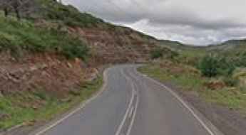
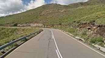
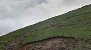
Travel guide to the top of Moteng Pass
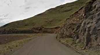
Moteng Pass is a high mountain pass at an elevation of 2.820m (9,252ft) above sea level, located in the Butha-Buthe District of Lesotho. It's one of the highest roads of the country.
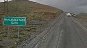
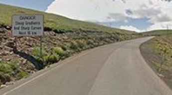
Mahlasela Pass: The Ultimate Road Trip Guide
Mahlasela Pass is a high mountain pass at an elevation of 3,278m (10,754ft) above sea level, located in the Butha-Buthe District of Lesotho. It’s a beautiful pass to drive, but be vigilant during winter as the road gets very slippery. It's one of the highest roads in Lesotho.
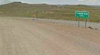
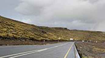
Tlaeeng Pass is one of the highest roads in Lesotho
Tlaeeng Pass is a high mountain pass at an elevation of 3.262m (10,702ft) above sea level, located on the boundary between Butha-Buthe and Leribe districts of Lesotho. It’s one of the highest roads in the country.
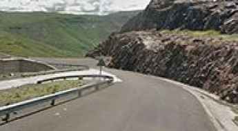
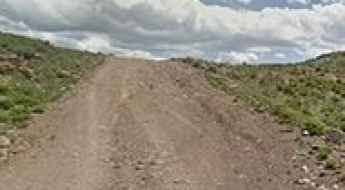
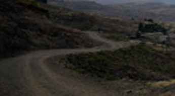
Baboons Pass is more suitable for donkeys than for vehicles
Baboons Pass is a high mountain pass at an elevation of 2.689m (8,822ft) above sea level located in the Maseru District of Lesotho. It’s one of the most remote, roughest and impassable passes of the country -- more suitable for donkeys than for vehicles. It's one of the highest roads in Lesotho.
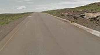
Driving the challenging road to Qacha's Nek border
Qacha's Nek is an international high mountain pass at an elevation of 1.989m (6,525ft) above sea level, located on the border of Lesotho and South Africa.
Steep gradients and sharp curves to Mafika Lisiu Pass
Mafika Lisiu Pass is a high mountain pass at an elevation of 3.096m (10,157ft) above sea level, located in the Leribè district of Lesotho. It’s one of the highest roads of the country,
The paved road to Kotisephola Pass in the Lesotho's Black Mountain
Kotisephola Pass is a high mountain pass at an elevation of 3.245m (10,646ft) above sea level, located in the Mokhotlong District of Lesotho. It’s one of the highest roads of Lesotho.
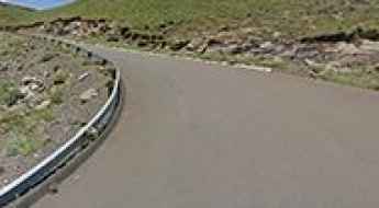
How to get by car to Mohale Dam in Lesotho?
Mohale Dam is a rock-fill dam located in the Maseru district of Lesotho. The road to the dam is paved and features 5 sharp hairpin switchbacks.
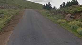
God Help Me Pass is a must-visit for road lovers
God Help Me Pass is a high mountain pass at an elevation of 2.292m (7,519ft) above sea level, located in the Maseru district of Lesotho.
Blue Mountain Pass: A Curvy Paved Road to the Summit
Blue Mountain Pass is a high mountain pass at an elevation of 2,641m (8,664ft) above sea level located in the Maseru district of Lesotho. It's one of the highest roads in the country.
The Ultimate Guide to Traveling Matebeng Pass
Matebeng Pass is a high mountain pass at an elevation of 2,960m (9,711ft) above sea level, located in Lesotho. It’s one of the highest roads in the country.
A Quite Steep Paved Road to Cheche Pass
Cheche Pass is a high mountain pass at an elevation of 2,545m (8,349ft) above sea level, located on the border between the Maseru and Thaba-Tseka districts of Lesotho.
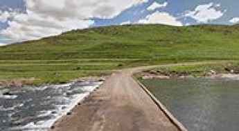
Semonkong-Mantsa Road bridges are often flooded away in rainy seasons
Located in the Maseru District of Lesotho, the road linking Semonkong and Mantsa includes many river crossings, with two of the most spectacular bridges in the world.
65 Bends to the Summit of Bushman's Pass
Bushman's Pass is a high mountain pass at an elevation of 2,266m (7,434ft) above sea level, located in the Maseru district of Lesotho.
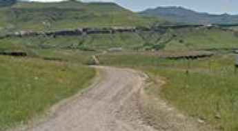
A Wild Unpaved Road to Menoaneng Pass in the Central Highlands of Lesotho
Menoaneng Pass is a high mountain pass at an elevation of 3,038 m (9,967 ft) above sea level, located in the Mokhotlong district of Lesotho. At this altitude, the drive is not for the faint of heart. It’s one of the highest roads in the country.
A Winding Paved Road to Mokhoabong Pass
Mokhoabong Pass is a high mountain pass at an elevation of 2,900m (9,514ft) above sea level, located in the Thaba-Tseka District of Lesotho. It's one of the highest roads in the country.
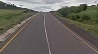
A3 Road is one of Lesotho’s top drives
Located in the central highlands of western Lesotho, the A3 highway is one of the main roads of the country.
How To Travel The Lebelonyana Pass
Lebelonyana Pass is a high mountain pass at an elevation of 2,463m (8,080ft) above sea level, located in the Quthing district of Lesotho.
Likalaneng Pass: Driving the high-altitude A3 road in Lesotho
Likalaneng Pass is a high mountain pass at an elevation of 2,638 meters (8,654 ft) above sea level, located in the Maseru District of Lesotho. Positioned in the rugged central highlands of the Maloti Mountains, the route through the pass is the fully paved A3 highway, which forces drivers to manage tight basalt rock cuttings, severe engine power loss, and sharp unprotected drops.
Nkaobee Pass: The relentless A25 road through Lesotho’s highlands
Nkaobee Pass is a high mountain pass at an elevation of 2,510 meters (8,234 ft) above sea level, located in the Leribè district of Lesotho. The road through the pass, known as the A25, is a grueling 105-kilometer journey that connects Ha Lejone with Thaba-Tseka. The physical reality of driving this route involves managing a weathered asphalt surface that is under constant attack from the extreme mountain climate, featuring a verticality that tests the engine's cooling system and the driver's endurance through hundreds of curves.
A5 road
A5 road is a very scenic journey in Lesotho. Climbing up to 2.756m (9,041ft) above the sea level, it’s one of the highest roads of the country.
Laitsoka Pass
Laitsoka Pass is a high mountain pass at an elevation of 2.644m (8,674ft) above the sea level, located in the Leribè district of Lesotho.
How difficult is the road through Monontsha Pass between South Africa and Lesotho?
Monontsha Pass, also known as Monantsapas, is a high mountain pass reaching an elevation of 2,247m (7,372ft) above sea level on the border between South Africa and Lesotho. This crossing separates the Free State province from the Butha-Buthe district, sitting right on the steep escarpment of the Drakensberg. It is a route of two halves: a modern climb on the South African side that suddenly vanishes into a raw, unmaintained 4x4 track the moment you enter the Kingdom of Lesotho.
The Road to Gates of Paradise Pass with Stunning Views of Real Africa
Gates of Paradise Pass is a high mountain pass at an elevation of 2,016m (6,614ft) above sea level, located in the Mafeteng District of Lesotho.
Can I Drive the 22% Grade Road to Mokhoro?
Mokhoro is a high mountain peak at an elevation of 2,541m (8,336ft) above sea level, located in the Quthing district of Lesotho.