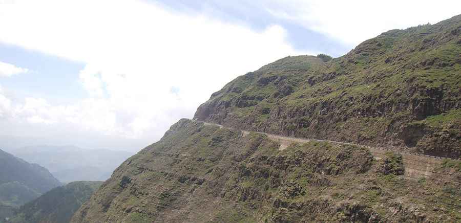
Driving the unpaved 3,551m China Road in Ethiopia
The B22 is a high mountain road at an elevation of 3,551m (11,650ft) above sea level, located in the Amhara Region of northern Ethiopia. This 294-kilometer route is one of the most challenging transits in the country, crossing the rugged highlands between Weldiya and Wereta. The road is a mix of deteriorating asphalt and long unpaved sections where the extreme altitude and the constant dust from heavy truck traffic test the cooling systems and air filters of any vehicle.
| Road facts: B22 Ethiopia | |
|---|---|
| Location | Amhara Region, Ethiopia |
| Elevation | 3,551 m (11,650 ft) |
| Length | 294 km (182 miles) |
| Surface | Partially Paved / Sand and Gravel |
Where is the B22 road located?
The road runs west-east across the heart of the Ethiopian Highlands. It connects Weldiya, the capital of the Semien Wollo Zone, with Wereta, a town located east of Lake Tana in the Debub Gondar Zone. The B22 crosses several mountain ranges where the terrain is dominated by deep canyons and high alpine plateaus. This is a remote and high-altitude environment where the infrastructure is basic and services are only available in the main towns at either end of the 294-kilometer journey.
Is the B22 unpaved?
The surface of the B22 is a source of constant difficulty. While some segments have been paved, large stretches remain unpaved, consisting of loose gravel, fine volcanic dust, and sand. The road is prone to heavy erosion during the rainy season, creating deep ruts and washouts that can trap 2WD vehicles. Even on the paved sections, potholes are frequent and large enough to damage wheels and suspension components. The high concentration of "calamina" (washboarding) on the dirt sections makes for a high-vibration drive that can loosen bolts and fittings over time.
Why is it locally known as China Road?
In the Amhara Region, the B22 is widely referred to as the "China Road." This name stems from the fact that Chinese engineering firms and labor were responsible for its construction and subsequent attempts at paving. The road was built to improve the logistical link between the northern highlands and the Lake Tana basin. Today, it remains a primary route for Chinese-built trucks transporting goods across the region, which contributes to the rapid deterioration of the surface and the constant presence of fine dust in the air.
How steep is the B22?
The road involves several massive climbs and descents as it scales the edges of the Ethiopian plateau. At its highest point of 3,551 meters, naturally aspirated engines lose about 35% of their torque. The ramps are long and sustained, requiring heavy-duty cooling systems to prevent the motor from boiling over in the thin air. The descents are equally technical, requiring constant engine braking to manage the speed of heavy vehicles on the loose, sandy curves. There are no safety barriers on the higher sections, where the road follows narrow ledges with unprotected drops into the valleys below.
What are the main hazards on the B22?
Beyond the technical nature of the road, the primary hazards are the unpredictable traffic and the weather. The B22 is shared by heavy trucks, buses, and local livestock, often on blind corners. During the rainy season (June to September), the sandy sections can turn into a thick, bottomless mud that makes the road impassable for days. Dust is another major factor; it clogs air filters quickly and reduces visibility to near zero when following other vehicles. It is mandatory to carry spare filters, at least two full-size spare tires, and auxiliary fuel for the 300-kilometer transit.
Pic: Peter Molnar