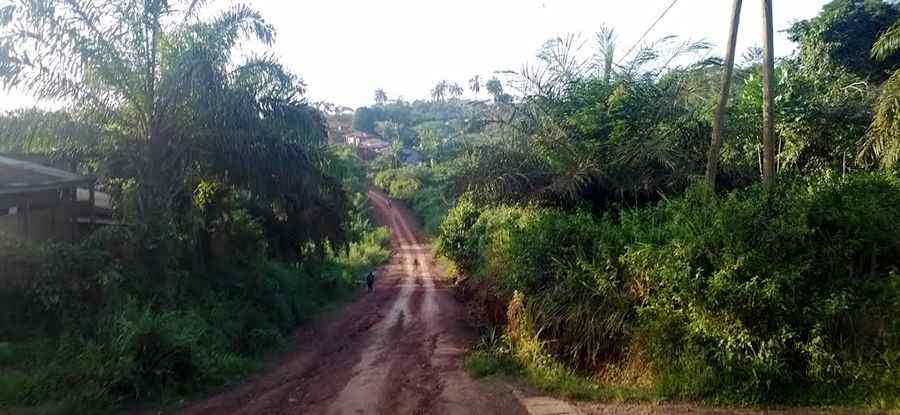
How to drive the unpaved Road P6 in Cameroon?
Road P6 is a supply route located in the East Province of Cameroon. Running for 308 km (191 miles) from Abong-Mbang to the iron ore deposits of Mbalam, the track crosses the heart of the rainforest through some of the most remote territory in the country.
| Road facts: Road P6 (Cameroon) | |
|---|---|
| Location | East Province, Cameroon |
| Length | 308 km (191 miles) |
| Surface | Laterite / Red Clay |
| River Crossing | Ferry over Dja River |
What is the surface of Road P6 like?
The road is entirely dirt, made of deep red laterite. This clay turns into a slippery soap as soon as it rains, making tires lose grip instantly. Massive iron ore trucks dig deep ruts that can be half a meter deep, so you need a high-clearance 4x4 with aggressive mud tires just to keep the axles from dragging. In the southern parts near the Congo border, the jungle canopy is so thick that the sun never hits the ground, leaving permanent mud bogs that can swallow a vehicle for days.
How do you cross the Dja River on Road P6?
There is no bridge over the Dja River. To get to the other side, you have to put the car on a ferry. Waiting times depend on the river's height and if the ferry's engine is actually working that day. During the worst of the rainy season, the current gets too strong and the crossing stops completely, cutting the 308 km drive in half. You must carry your own fuel, water, and food, as there are no shops or workshops once you leave the main towns.
What are the hazards of driving to Mbalam?
The biggest danger is meeting logging and mining trucks on the narrowest parts of the P6. These heavy rigs stay in the middle of the track to avoid the crumbling edges, forcing you to maneuver on the soft, wet shoulders of the road. You need to be ready to fix your own car; carrying two spare tires, a winch, and sand ladders is the only way to survive the sections where the red clay has been churned into a swamp by the big wheels of the trucks.
Is the Road P6 open when it rains?
The road stays open, but a heavy storm can turn the 308 km trip into a journey of several days. When the mud gets too deep, the road becomes a trap even for the best 4x4 vehicles. The section south of Abong-Mbang is known for washouts where the water simply eats the roadbed overnight. Visibility is always poor, either because of the dense jungle trees or the huge clouds of red dust kicked up by trucks during the short dry spells.
Pic: https://static.panoramio.com.storage.googleapis.com/photos/large/120280140.jpg