Mount Chelia: Driving the 2,293m unpaved peak in Algeria
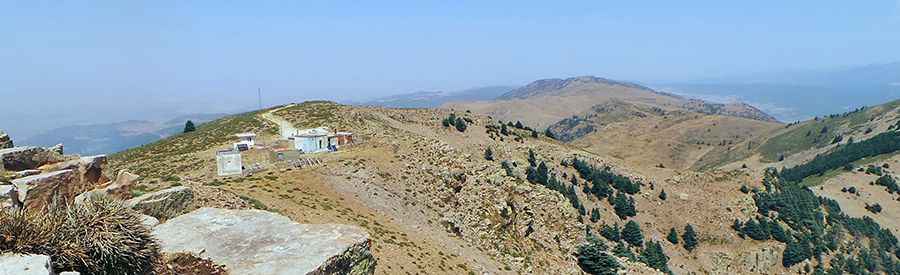
Mount Chelia is the highest mountain peak in northern Algeria, reaching an elevation of 2,293 meters (7,522 ft) above sea level. Situated on the border between the Khenchela and Batna provinces, the track leading to the summit is a raw, unpaved mountain path that forces vehicles to climb steep ridges, deep ruts, and sharp limestone fields within the Aurès Mountains.
| Road facts: Mount Chelia | |
|---|---|
| Location | Aurès Mountains, Batna / Khenchela borders, Algeria |
| Elevation | 2,293 m (7,522 ft) |
| Distance | 7.6 km (4.72 miles) from Col de Bouhmama |
| Average Gradient | 7.35% |
| Surface | Unpaved loose dirt, limestone rocks, and dust |
How rough is the 7.6-km climb to the summit of Mount Chelia?
The unpaved mountain track begins right at the asphalt turn-off of the Col de Bouhmama. From this point, the road gains 559 vertical meters over a short 7.6-kilometer drive to the peak. The climbing slope is continuous, averaging 7.35% with specific hairpins hitting harder ramps on loose ground. The surface is a broken layer of sharp limestone rock shards mixed with fine white dust that robs tires of grip, causing wheels to spin out if the vehicle lacks a proper low-range four-wheel-drive system.
How does the Algerian weather change the Mount Chelia track?
The track is completely exposed to the extreme weather shifts of the desert mountains. During the summer, temperatures regularly cross 40°C, causing radiators to boil during the slow low-gear climb. In the winter months, heavy snowstorms pack the high ridges, burying the dirt path under thick ice banks and making the route completely impassable until late spring. Sudden mountain cloudbursts turn the dry limestone dust into a grease-like mud coating that causes trucks to slide sideways off the lane, while flash floods frequently wash out the track edges, leaving deep drops right on the shoulder line.
What infrastructure dangers exist on the road to Mount Chelia?
The final stretch to the peak follows a narrow shelf cut directly into the mountain face. The lane narrows down to a single vehicle width with zero steel guardrails or side concrete barriers, leaving tires inches away from vertical drops into the canyon brush. There are no passing bays or wider switchbacks to turn around if you meet another truck coming down. The track terminates at the desolate summit next to abandoned military and telecommunication concrete buildings, where there is zero mechanical help or mobile phone service if a sharp stone punctures a tire sidewall or damages the vehicle undercarriage.
Pic: Ahmed Rouibi