Driving the N-31 road through Col-Ain-Tinne in the Aures region
Col-Ain-Tinne (also known as Teniet Bou Irhyal) is a high mountain pass reaching an elevation of 1,686m (5,531ft) above sea level, located in the Batna province of northeastern Algeria. Situated in the heart of the Aures region, the pass follows the Route Nationale 31 (N-31), crossing a spectacular limestone gorge with extreme vertical walls.
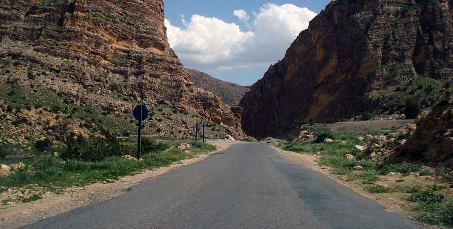
| Road facts: Col-Ain-Tinne (N-31) | |
|---|---|
| Location | Batna Province, Algeria |
| Elevation | 1,686 m (5,531 ft) |
| Road Number | Route Nationale 31 (N-31) |
| Length | 8.7 km (5.4 miles) |
| Surface | Paved / Deteriorating shoulders |
Is the N-31 road through Col-Ain-Tinne paved?
Technically, the 8.7 km (5.4 miles) road through Col-Ain-Tinne is totally paved, but the asphalt quality is subject to intense thermal stress and rockfalls. The route, running south–north from Mardj hamath to Tzouket, features steep gradients and extremely narrow sections where the limestone cliffs drop directly onto the roadbed. Logistically, the absence of modern safety barriers and the presence of loose gravel on the shoulders make the N-31 a high-precision drive, especially for heavy vehicles transit through the Aures mountains.
How challenging is the drive through Col-Ain-Tinne?
The Col-Ain-Tinne pass is a demanding drive due to its unique topography. As seen in the narrowest sectors of the N-31, the road is hemmed in by massive rock formations that limit lateral visibility. Technically, the 8.7 km stretch requires constant attention to oncoming traffic, as the paved surface narrows significantly inside the gorge. Logistically, the road is prone to sudden rock slides after rain, and the lack of lighting or signaling in the remote sections of the Batna province increases the risk during night transits or low-visibility conditions.
Is the road to Col-Ain-Tinne open year-round?
Positioned at 1,686m, the N-31 through Col-Ain-Tinne remains open for most of the year, but winter can bring localized snow and ice to the Aures region. Logistically, the main threat is the high-altitude weather shifts that can turn the steep paved sections into low-traction zones. Technically, the descent requires careful gear selection to manage brake temperatures, as the sustained incline and the narrow roadbed offer zero runoff areas for mechanical emergencies. Always monitor local weather reports before heading north from Mardj hamath toward the summit.
Pic: https://mapio.net/pic/p-21314274/